Tuesday, December 27, 2011

Will the Midwest be taping into some heavy arctic air next week?


‘Heavens to mergatroid’, as Snagglepuss might well have put it,' there’s a change in the air over America next week!' At any rate, advanced National Weather computer modeling seems to portend an ‘incursion’ of very cold arctic air arriving my way on or about the fourth of January! And yes, by golly, there might even be a bit of moisture coming along with this changing of the guard!

Stay tuned! It only gets more interesting from here and, remember,,, Only the most faint of heart would dare make these half-assed forecasts that I do! Well...never mind! I've already fainted....

Monday, December 26, 2011

Snow possible for December the 26th


This time of year as we head closer to the winter icebox that is January, a light snow is forecast to fall from a pesky little area of low pressure over night Monday and possibly into the morning hours of Tuesday, December the 27th. Accumulations of up to an inch on grassy surfaces may occur although the timing and temperature levels could go either way from snow to rain and even back again.

In either case it will be a wet, cold and overcast beginning for the start of the last week of 2011. The light in the tunnel right now is that we can expect moderate and even warm conditions as we finish out the week!

Sunday, December 25, 2011


It is my hope that the coming year will see a resurgence of belief in God and in his Son who died on the cross for our sins. May 2012 also be a year where the people of this great nation come together and work for the betterment of all. Amen!

Friday, December 23, 2011

Post Christmas Wx looks to be above normal!

A couple of day before the Christmas Holiday, all seems quiet on the western front. The forecast for much of the Midwest is for clear and moderate conditions on though much of the week to come. There is a bare chance of some snow flakes mixed with rain as a fast moving low pressure system moves over southern Missouri on the Monday (December 26th) time frame. After that, however, it looks to be clear sailing with above normal temperatures as a zonal weather flow sets up across the middle of the nation.

Thursday, December 22, 2011

December temps moderating for last part of the month!


It should as the temperature for the first three weeks of the month have been running well above average and the third week was way out there with temperatures averaging 8 degrees higher than normal! That’s been true in southwest Missouri anyways. Now, while I’m no fan of global warming, I’ll still take that over global cooling any day. The fact is it’s a lot cheaper to cool a home than it is to heat one. This year my total electric bill is on tack to be about 30% less than the year before. Savings that I can really use!

With just one more week or so of the month to go, the weather professionals are calling for moderating temperatures which means warmer than normal temperatures and I can certainly live with that!

Wednesday, December 21, 2011

Winter forecast for 2011-12

Yes, it's time for the weather forecast for the coming winter of 2011-2012, which I would like to remind everyone, is right around the corner! The following post represents paraphrased and copied wording from information I gleaned off reliable sources. It may or may not be accurate in all regards. I like to post these to see, months from now, just how accurate they were.
--------------------------
Beginning with trends, last winter was the coldest in 30 years across many parts of the US. Some eastern parts of the US plunged to a record -50F with the Northeast of the US also seeing many records broken. Temperatures, in general, were below normal for large Midwestern and Eastern cities like New York, Chicago, New Orleans, and Minneapolis. Snowstorms shattered records in New York City in December 2010 and January 2011 to make January the snowiest ever recorded.

So let me turn to the US winter forecast for 2011/2012.

La Niña cooling the equatorial seas of the Pacific and was one of the strongest on record during 2010/2011. (Less warm air rises during La Niña conditions with a cooling influence on the atmosphere that has big implications on global climate and global weather patterns). The changes in global weather patterns originate from air pressure changes in atmospheric cycles known as the North Atlantic Oscillation (NOA) and Arctic Oscillation (AO).

The latest National Oceanic and Atmospheric Administration (NOAA) data suggests neutral conditions ahead, but a negative Pacific Decadal Oscillation (PDO) may yet suggest otherwise. (The PDO is a pattern of Pacific climate variance that recently switched to negative (cold) and will remain that way for the next two to three decades). It is considered likely that La Niña will return more frequently during this time period as a negative PDO results in stronger La Niña (cooling) and weaker El Niño (warming) episodes.

Another fly in the ointment is the current low period of solar activity we find ourselves in. Lower levels of solar output act as a primary driver of atmospheric cycles that influence blocking activity patterns/ridges.

Meteorologists, as they consider all of these factors, are currently leaning towards a particularly harsh winter for many parts of the US during 2011-2012. Large parts of Central and North America will face below average temperatures with above average snowfall throughout this winter Temperatures in many Eastern and Western parts of the US are also continued to be forecast below average with above average snowfall amounts.

The Pacific Northwest region will not escape as the scientists also predict this region will experience a very severe winter, including the Cascades snow pack which is likely to see increased levels due to the negative (cold) phase of the PDO.
--------------------------
The bottom line is most everyone may get some measure of extreme weather this coming winter; so get out there and buy yourself a heavy duty snow shovel, or better yet, book an extended stay in the Bahamas!

Note: For anyone with an interest, here is what I wrote about last winter (2010-11) which was based on the Farmer's Almanac. Also, in late October, NOAA has released this update!

Tuesday, December 20, 2011

A blizzard in the heartland of America signals the start of winter!


It seems Old Man Winter was just a day early as a major winter storm barreled across some mid western states on December the 20th. Snowfall totals exceeded a foot as whiteout conditions were observed in states like Colorado, New Mexico and Oklahoma. The question now is whether this storm is the beginning of a snowy trend or just an early fluke of nature?

One thing is for sure. The temperatures in my neck of the woods have been warmer than normal. A trend that was observed in October and continues to the day of this post. In December alone the average temperature has been five degree higher than historical standards. We’ve also had plenty of rain; over nine inches all told in November and December as of the 20th.  Now, while this system has brought only rain to southwest Missouri, there is another system that is expected to coming through on the 23rd that might give off a bit of the white stuff.

Friday, December 16, 2011

Winter weather more likely now on Monday Dec 19


After looking at some of the grids and after making some wild guesses, I think there is an increasing likelihood for snow or sleet or ice to impact portions of southwest Missouri as early as Monday evening, December the 19th. While the exact track and type of precipitation at still up in the air, the odds are that Missouri locations along a belt extending from a Cassville to Salem line will be battleground central.

Whether or not this will pan out is anybodies guess. But, it will be fun tracking the low pressure system coming out of the Baja region of California beginning sometime over the coming weekend.

Following is some of the latest professional discussion from the NWS:

“As it stand right now...a track from Cassville to Salem would yield a period of rain on Monday and on Monday night...with precipitation changing to snow as cold air streams in behind the surface low and a well developed 'TROWAL*' structure moves over much of Missouri.

Obviously...the surface track will likely change from its current depiction in the computer "Model World"...and even just a small change either north or south will cause a drastic change on thermal profiles and the precipitation type...as well as surface temperatures and thus any wintry precipitation accumulations.”

*Trough of Warm Air ALoft. Typically used during winter weather, it is a "tongue" of relatively warm/moist air aloft that wraps around to the north and west of a mature cyclone. It is best analyzed between 750-550 milibars using equivalent potential temperature (theta-e). Areas of intense lift and frontogenesis are commonly associated with TROWALs, hence they are favored regions for heavy and/or prolonged precipitation. During a winter storm, the heaviest snowfall amounts frequently occur along and north of the TROWAL axis.

December 18 followup: Still looking good for some snow to impact the I-44 corridor by late Tuesday or early Wednesday. Heaviest snow looks to be in Texas panhandle region at this time.

December 19 followup: It now looks as though parts of AZ and NM will get his with lots of snow with blizzard conditions possible is some areas. Also impacted, at this time will be parts of western Kansas. The forecasted northerly track of this storm would seem to indicate that  southwest Missouri will miss out on much of the wintry action settling instead for a mostly rain event.

December 20 followup: Now looking like the system of snow will pretty much miss Missouri entirely. Still, it did pack quite a punch in some of the states off to the west!

Thursday, December 15, 2011

Someone may get hit with winter right before it’s actually winter!


Does that make sense? Right now not even the big weather computers have a clue on what might transpire on or about December the 20th. That’s where good guessers (not geezers) like me come into play. So here I go.

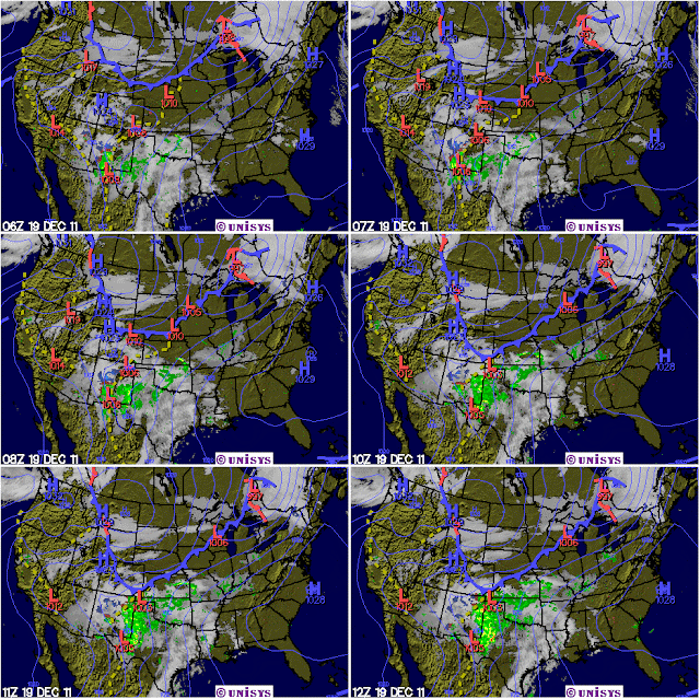
This composite radar image for the northern hemisphere looks interesting to me. Two features in particular caught my gaze. One, the lower jet of the coast of California looks to be rather healthy. It can often serve as a transport for moisture across the lower forty. Second is the low pressure center currently just off the southern shores of Alaska. I wonder if it will be a player for the early next week time frame (five days from now)?

Now, according to my informed sources (a woolly worm), the thinking is for the development of a cutoff low somewhere off the southern California coast that may persist there for a time before it gets kicked out to travel across the southern states, bringing moisture with it as it does. The timing, as usual, will be everything, but I clearly think there’s a chance that this wet puppy will meet up with a large cold air trough barreling down from the northwest. The end result could be wintry precipitation for some lucky state or states.

December 2011 Weather recap for first two weeks!


If I had to say in a word what the first two weeks of December 2011 were like I would have to say cloudy and dull. But, that’s would be saying a good thing main due to the fact that cloudy days in the wintertime often translate into warmer temperatures. Did that happen this year?  Why yes! We were almost four degrees warmer (West Plains data, not Springfield used for this comparison) than the 30 year average of 35F. This graph also compares 2010 to this year and yes it has been warmer. Hopefully this will translate in to lower electric bills by month end. One can only hope.

Precipitation thankfully has also been plentiful. With three inches in the book, we only need another inch to hit the target of about four inches to make this an average month in that department. Forsyth Missouri has been the beneficiary of a narrow band of periodic rainfall  that has been swept in on the cold fronts. I’m thinking that people living to the north of my location have not been as fortunate. The state of Texas is still caught in a drought situation that some say may worsen with time…

Sunday, December 4, 2011

Midwest headed for the deep freeze?

After a brief flirtation with wintry precipitation on Monday, December the 5th, we will finish the rest of the week dry but colder than normal. This will be due to the weather patterns that will feature a cross polar flow which will usher in very cold polar air in a series of waves with nothing to stop them. Combined with this feature will be a gulf that is shut off as far as moisture in concerned. This pattern should persist through the Saturday, December the 10th when a new shift could bring warming temperatures once again.

This pattern of chill down followed  by warmups  could well set the stage for some interesting winter weather as we approach the middle of December!

Saturday, December 3, 2011

Get prepared to see some flakes!


[click to enlarge, and no it's not a penis]

Now, I’m not talking about people! Goodness knows we have enough of those around where I live in SW Missouri! No, I'm referring to snow flakes. Lots and lots of snow flakes as it may turn out.

That's the current thinking of the National Weather Service out of Springfield Missouri. Somewhere around one inch is possible over a wide area beginning sometime on Monday, December the 5th in the early hours. That is assuming it doesn't all melt as it lands on ground that is still fairly warm! The probability of this occurring stands at 40% as of this point in time.

Behind this cold front, that will pass through the Forsyth area late Sunday, will be a blast of rather frigid air, courtesy of our friends to the north! Darn those Canadians.

Followup: As of early morning Monday, December the 5th, it is becoming apparent that no snow will accumulate anywhere in the southwest Missouri corridor. Having said that, it was still a close thing. You have to give credit to just how good the weather guys have gotten over that past decade!

Followup: I was amazed to see a little bit of snow cover the morning of December the 6th! Tiz the Season!

Friday, December 2, 2011

Light snow possible for December 5th and 6th!


Ah, so good to hear the ‘S-word’ this early in the season. With winter not even starting until the 21st of the month, here we have a chance for a ‘couple of shots’ of snow sometime this coming Monday and Tuesday. Right now that’s just a best guess from the National Weather Service, but they insist that ‘no matter what computer model prevails’, we will be getting progressively colder by next week!

Thursday, December 1, 2011

November Weather Summery for Forsyth for 2011

Location: Forsyth Missouri 65653

 [click to enlarge]

If one were to accept Global Warming as fact, then the month of November for 2011 was ‘normal’. The temperature mean for the month was 49°F versus a historical average of 45°F. So, we were 4 degrees warmer than the average. One interesting side note was that while the daytime temps were cooler than normal, the nighttime was much warmer than normal.

The month was also wetter with 5.6 inches of precipitation against a 30 year average of 5.9 inches. (Note that I am using source data for West Plains Mo. Rather than Springfield).

This pattern of ‘wetter’ and warmer runs against other indicators including the state of waters off the South Americas. Right now we are in a La Nina phase which would normal indicate dryer conditions for the Central United States.

Disclaimer: All data in the table of figures was obtained on location using a Davis Weather Monitor II station along with software by Ambient. The author is not responsible for the accuracy reported in this blog. It is intended for recreational interest only.

Tuesday, November 29, 2011

The cold comeith!

Forsyth Missouri – Saturday, November the 26th marked a turning point on what had been a rather nice regime. What had been a warm and fuzzy environment became, quite suddenly, a blustery cold shoulder that was much more in line with the time of year. It was, after all, late Fall and Old Man Winter was a knocking at the door.

While I was dozing a rainy and overcast afternoon away, long about 3:00 pm, the winds which had been idling out of the east suddenly shifted into high gear from the north! I awakened to find the mercury dropping rather smartly from a nice 59F to a chilly 43F in rather short order. Ah, I thought at the time, the party she is over.


Note the abrupt change in the temperature profile at 3PM. This clearly marked the passage of a trough behind which cold Canadian air filtered in. A steep pressure gradient aided in helping to keep the winds gusting up to 15 mph with a sustained flow at about 6 mph.

Sunday, November 27, 2011

The Weather regime is changing in late November 2011


Someone must have inadvertently hit the switch a little early this season as I am seeing a marked change in the weather patterns. I think cold and unsettled would be two good descriptors to use.

What had been warm and balmy conditions with highs reaching the upper fifties and low sixties the last full week of November, now a change seems to be on hand as the area here in southwest Missouri should experience a series of re-enforcing cold shots from upper level troughs over much of next week. This will keep the temperatures in only the forties for the daytime and into the 20’s at night. Then, towards the weekend another active system is expected to make an entrance along with increased chances for precipitation. The only question I have is what form the precipitation will take!

That weekend, by the way, will put us into the beginning of December with only a few weeks to go before the first day of winter begins on the 21st. Now would be a good time to make sure you have stowed some winter essentials into your vehicle in case the weather gets nasty while you’re out.

Saturday, November 26, 2011

Sliding into Winter!


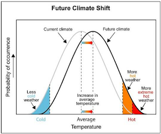
Somewhere between the end of November and the 21st of December when winter officially begins we see things getting a little bit nasty. The combination of longer nights with the higher angles of sunlight striking the ground turn the northern hemisphere of earth much colder on average than what they are in the summer months. Add to this the effects of global warming which shift the curve of extreme weather to become more likely and you have a recipe for some interesting wintertime events to occur. In my part of the world, that would translate quite often into ice storms.

So am I saying that we will experience more ice storms for the winter of 2011-12 here in southwest Missouri? No, I saying that the ODDS are getting more and more stacked in that direction. So, while we might have a nice mild and dry winter, the odds are increasingly against it.

Thursday, November 17, 2011

CO2 as a benchmark for changes in climate!

"We are experiencing the greatest wave of extinctions since the disappearance of the dinosaurs. Extinction rates are rising by a factor of up to 1,000 above natural rates. Every hour, three species disappear. Every day, up to 150 species are lost. Every year, between 18,000 and 55,000 species become extinct. The cause: human activities." (Ahmed Djoghlaf, head of the U.N. Convention on Biological Diversity)

[click to enlarge]

I read somewhere that weather is the day to day reality of climate. While you can observe one the other stays well hidden. So, when a climatologist is asked pointedly if global warming is a fact, they cannot answer the question. But, if you were the rephrase it and ask, ‘are climatic trends loading the odds in favor of a warmer climate?’ You would more than likely get a positive answer.

Since I am not a scientist and therefore lack any credibility, I’ll answer the first question more matter of factly. ‘You bet you fanny it’s getting warmer and the worst is yet to come.’

I can say that not only because I’m not a scientist but also because you don’t have to be one to figure out that the species known as man is spewing carbon into the atmosphere as fast as he can go. There's an estimated 7 billion of us cooking and heating with gas, oil or coal or just finding whatever it is we can burn. As the earth warms from this activity, the weather tends to become a little more severe and even occasionally flaky. What's this mean for the future of the planet?

Looking at an ice core graph taken from Vostok, Antarctica, you can tell by the blue line that the amount of CO2 in the air in parts per million has never reached much above 300 ppm (red line) in over four hundred million years! It’s also pretty easy to see that every time those readings went up to that level, the earth was quickly plunged into another ice age. Looks like a pretty regular pattern doesn’t it? First the CO2 rises as does the global temperatures and then, in a relatively short time, down everything goes into the ice freezer. Now, while there are all sorts of theories as to the actual mechanisms at work here, everyone agrees that the CO2 levels along with other indicators like methane are good benchmarks to use. Anyone want to guess where the CO2 level is at today (see small graph)? Here’s a hint:


One other point. With a world population that is expected to rise to 9 billion by 2050, it's hard to see how we are going to curb carbon emissions to any significant degree. And, even if we could manage that miracle, many resources like food and fresh water will certainly become more scarce. Famine, disease and war could well become the norm. Not a very pretty picture for the future of this planet and it's inhabitants. While I think most adults now living will escape the direst of these futures, certainly our children and their children may face a perilous existence that would be brutal and short.

What's the answer to all my doom and gloom? Immediate and severe population control! We need the human population of earth to be cut in half, at the very least, over the next one hundred years. This can be done by the hand of man or by nature or of God. If man is going to do it, he'd better get on his high horse because time is flying by. My personal bet is on Nature and God.

Tracking the weather in a simple data file!

 [click to enlarge]

One of the fun things I do on a daily basis is to summarize the day with some simple text and graphics. Here is a sample for Nov 17, 2011. Note the weather radar for that date in 2000.

Tuesday, November 15, 2011

Mid November Weather Summary for 2011 in Forsyth Missouri


Eight degrees would be a good place to start when describing the weather for the first half of this month here in Forsyth Missouri. That’s eight degrees Fahrenheit warmer than the normal of 45°F (source: West Plains, Mo. average). What’s somewhat interesting is that while the highs where not far out of the range, the nighttime temperatures were markedly warmer (only three days oiut of the 15 below the average low mark). Food for thought concerning global warming.

November is also starting out strong in terms of precipitation with3.69 inches recorded already against a monthly average of 4.92 inches giving us just 1.23 inches to go.

The turning of the leaves was one of the best in my memory, but by the fifteenth, they have all pretty much been stripped from the trees. Strong gusty winds over the last few days helped that process out a lot!

While I’m as far from being a weather scientist as you can get, I do pay attention when other experts talk and try and be as objective as I can from observations I make directly. My gut feeling is that, yes it has been warmer than normal. I’ve also seen this expressed in plants in my garden that should have been history by now, but which are still growing!

Having said that, I did notice that the latest Arctic Oscillation graph looks to be more and more negative. Does that portend nastier than normal things to come? I  don’t know and neither does anyone else, although some would say that the odds are being stacked more and more in that direction. Time will tell on that observation.

Wednesday, November 2, 2011

A good start for November 2011!


 The last couple of days have been good ones! At least weather wise. The first and second days of November 2011 were pretty much ‘picture perfect’ as far as I was concerned. On the 1st, I went down below my house to the River Run Park area for a nice walk in my short sleeves. The winds were somewhat playful on the 74F day. They’d switch direction more often than a woman changes her mind. But, I didn’t find that a problem. For the most part they were light and most importantly, they were warm!

While others were hard at work on this Tuesday after Halloween, I had the good fortune to be out here, sitting on a concrete bench at a campsite taking in the sights and sounds of fall. With me were just a couple of people; a young girl and her dog out walking and someone (not sure of the gender) who appeared to be asleep in the back of her vehicle. Just a pair of stocking feet stick out the back to attest to the fact!

As I sat there, I could tell that fall was well on its way with colder days just ahead. Most of the trees around me; sycamores, maples oaks and the like have all changed color not with a few trees completely stripped. Thank God for the cedar trees that stay green year round!
----------
On Tuesday, I decided to drive down past the park and have a light lunch by Swan Creek. A creek in name only as it was completely dry on this date. As you can see, the recent flood did a number on the road! Also, many of the trees are dead in this area due to flood water that persisted for months on end.

While this afternoon was not quite as nice as the day before, it still beats the heck out of what’s coming later today when a mean old cold front come barreling out of the northwest! I understand the states of Colorado


 and Nebraska both got a dose of snow. A little early for all that nonsense, but Mother Nature does her thing no matter what I say!

Tuesday, November 1, 2011

National Weather Service uses the 'S' word for the first time this season!


Well, they’ve gone and done it! The National Weather Service for the Springfield Missouri area has used the ‘S’now word for the first time this season. Seems that Wednesday night, November the 2nd might see a chance of some snow flurries as a projected storm system moves through the region.

If that does come to pass, it will be one of the earliest occurrences of snow I can remember in quite some time. Here’s the exact quote, “Main concerns are fire weather today and rain/TSTM chances Wed/Wed night (and a little bit of snow Wed night??). Later concerns are another frontal passage over the weekend...then more rain chances next week.

Ah, snow in the first days of November! Yeah, that sounds about right!

October 2011 Wx Recap for Forsyth Missouri


Location: Forsyth, Missouri

October 2011 turned out to be a pretty normal month when compared to historical averages. The mean temperature for the month was 56°F as compared to a historical average of 57°F. (source: West Plains, Mo.). Just a degree cooler. Rainfall lagged behind the normal amount, as I recorded only 2.65 inches against an average of 3.39 inches (data also from West Plains, Mo.). So, we were a little dryer than normal, a trend that the weather service thinks will carry on through the balance of this year.


Energy Use

I was surprised, in a good way, with the fact that my use of electricity came in at only 395 kilowatts for the entire month! This represented a 44% reduction over the year before! So, I hopefully doing something right in my efforts to reign in my energy cost.

November 2011

Looking ahead, I’m pretty sure the month of November will pose an even bigger challenge as the mean temperature looks to drop twelve degrees from 57°F to 45°F. This will mean that some of the nighttime temperatures may likely flirt at or slightly below freezing on some days which is also the lower limit of the efficiency rating for my heat pump. On those cold days, I plan to implement my ‘space heater plan’ (see a Roomy Experiment) to help keep the costs down. It’s interesting to note that last year I used 922 kilowatts of power in a month that saw a mean temperature of 48.5°F versus a historical average of 45°F. I can always hope that this year will turn out to be even a little warmer than 2010 was.


A parting word on the Arctic Oscillation – it turned negative for the last week of October. Just in time for that ‘rare’ snowstorm that took eleven lives and plunged millions into darkness when the power failed. I’ll keep a close eye on this in the future.

Monday, October 31, 2011

What to expect for November in the way of weather!

Ah yes, November! A most interesting month. In many ways it's like March only November comes in like a lamb and can leave like a lion! Expect pretty nice and warmish temperatures through the first two weeks of this month and then watch out as the night times get seriously cold just before the end of the month (see graph of Nov 2010). 


 The average high is 57F and the average low is 33F where I live in southwest Missouri. However, that figure is skewed somewhat with the warmer stuff coming early on, followed by rapidly cooling conditions late. The reason; more and more aggressive incursions of cold air from the northwest in the form of fronts that also bring moisture as a consequence. Expect rainfall to be close to four inches as a result. Note: Last year was a little dry at about 2.50 inches!

So, think cold and damp as one way to characterize November. Ergo, not my most favorite month, but still way out ahead of the evil trio that is December through February. Please remember though, that just as as this month is often humid, so it is that cold dry air will soon follow. Time to make sure you have a humidifier in good working order. I have an old Duracraft DH799 unit that uses three filters that have to be replace every year. I also need to remember to order a bottle of anti-bacteria solution. Sometime in early December, I'll have this unit running pretty much full time to help keep the air in my home moist. This actually helps my heat pump out as the air will hold heat better if the humidity is at 40% or there about. For more on that, please see my article on moisture control.

Sunday, October 30, 2011

Freak East Coast storm or part of a pattern?


October 29, 2011 - The northern section of the east coast was slammed with what they termed a ‘rare nor’easter’ that killed three people and left millions without power.  But was it really? Or, was this the opening shot of what could be a very strange winter for North America?

Read more on this story here!

Sunday, October 16, 2011

Like a Yo-Yo, the weather will be up and then down and then…!


After hearing the words ‘unseasonably warm’ for the better part of a week, get ready for the warm part to become the unseasonably cold part.

The National Weather Service has announced ‘colder than normal conditions’ can be expected starting about Wednesday of the coming week as a Canadian air mass makes an incursion into the Midwest. Morning temperatures on Thursday may be below freezing, especially in low lying areas. So, be prepared!

Saturday, October 15, 2011

First two week weather recap for October 2011!


The month of October averaged about 4 degrees F. warmer than what is the historical standard. This made it a great month to be outdoors as most days were clear, dry and pleasantly warm. Yet, we also had enough rain to keep us about where we need to be in that department. The month of October normally sees about 3 1/3 inches of rain, so we need only about two more inches to make that target.

This trend for warmer than normal weather should continue until about Tuesday, October 17th when colder conditions will begin to take hold. The weather service is predicting highs in the fifties and lows approaching the freezing mark.

I also thought to include the current Arctic Oscillation Index (AO) for informational purposes:

 I've noted that all the models are trending towards a negative index. This would seem to indicate the potential for colder than normal conditions coming in the near future.


Friday, October 14, 2011

Overnight temps to hit freezing mark for the first time!


As early as Tuesday, Oct the 18th or as late as Thursday, the National Weather Service expects to see the outside overnight temperatures to get close to or at the 32F mark for the first time this fall. Last year in 2010, this did not happen until the 29th.

While there is no significance to this, it will be interesting to follow the mean weekly temperatures as we get into the month of November.

In the meantime, anyone who wants to protect cold sensitive plants may want to cover them by the 18th .

Wednesday, October 12, 2011

October 12, 2011 dawns with the crack of thunder and lots of rain!


Starting at around 5:30 AM in the Forsyth, Missouri area loud and sharp air to ground lightening strikes intensified as they responded to a frontal trough. I have to say that the thunder had a real hard sounding quality to it and, as is normal around here, we lost power for about half a minute. Actually, make that twice as a close lightening strike knocked it out again for a second as I was writing this post. Shocking enough to make your heart stop!! This sort of thing happens with regularity as the local coop, Empire Electric, seems to have only the most tenuous grasp on its electric grid. (When I lived in Chicago with Com Ed, it would take a blizzard to kill the power). Thinking of which, should we experience a hard winter, I cannot imagine this utility working all the time and so would urge everyone to go out and buy a good backup generator.

Along with the thunder came rain, with a real downpour occurring at about 6AM. This didn't last long as the severe part of the system moved quickly on through the area. Behind it were occasional short-lived downpours interspersed with light periods of rain that continued on into the morning hours.

The rainfall for the month, as of noon, amounted to 2 inches in a month that normally sees 3.4 inches. We still have a couple of weeks to go, so I'm hoping we'll hit that mark. This was good to see as I think most everyone would prefer a wet fall over a dry one. I'm not as sure, however, if that would be a good thing should it get carried into the coming winter period as that could easily spell ice! (Note: Last October saw just .56 of an inch of rain and most of that fell on the 26th of the month).

Temperatures during this storm hovered at around 60F. Temperatures for this date expected to get up to 70F or so before a cold front makes it appearance later in the week.