

After looking at some of the grids and after making some wild guesses, I think there is an increasing likelihood for snow or sleet or ice to impact portions of southwest Missouri as early as Monday evening, December the 19th. While the exact track and type of precipitation at still up in the air, the odds are that Missouri locations along a belt extending from a Cassville to Salem line will be battleground central.
Whether or not this will pan out is anybodies guess. But, it will be fun tracking the low pressure system coming out of the Baja region of California beginning sometime over the coming weekend.
Following is some of the latest professional discussion from the NWS:
“As it stand right now...a track from Cassville to Salem would yield a period of rain on Monday and on Monday night...with precipitation changing to snow as cold air streams in behind the surface low and a well developed 'TROWAL*' structure moves over much of Missouri.
Obviously...the surface track will likely change from its current depiction in the computer "Model World"...and even just a small change either north or south will cause a drastic change on thermal profiles and the precipitation type...as well as surface temperatures and thus any wintry precipitation accumulations.”
*Trough of Warm Air ALoft. Typically used during winter weather, it is a "tongue" of relatively warm/moist air aloft that wraps around to the north and west of a mature cyclone. It is best analyzed between 750-550 milibars using equivalent potential temperature (theta-e). Areas of intense lift and frontogenesis are commonly associated with TROWALs, hence they are favored regions for heavy and/or prolonged precipitation. During a winter storm, the heaviest snowfall amounts frequently occur along and north of the TROWAL axis.
December 18 followup: Still looking good for some snow to impact the I-44 corridor by late Tuesday or early Wednesday. Heaviest snow looks to be in Texas panhandle region at this time.
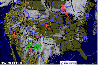
December 19 followup: It now looks as though parts of AZ and NM will get his with lots of snow with blizzard conditions possible is some areas. Also impacted, at this time will be parts of western Kansas. The forecasted northerly track of this storm would seem to indicate that southwest Missouri will miss out on much of the wintry action settling instead for a mostly rain event.
 December 20 followup: Now looking like the system of snow will pretty much miss Missouri entirely. Still, it did pack quite a punch in some of the states off to the west!
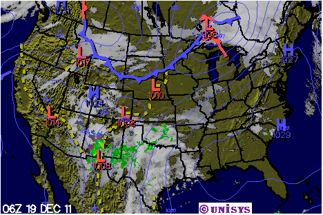
December 19 followup: It now looks as though parts of AZ and NM will get his with lots of snow with blizzard conditions possible is some areas. Also impacted, at this time will be parts of western Kansas. The forecasted northerly track of this storm would seem to indicate that southwest Missouri will miss out on much of the wintry action settling instead for a mostly rain event.

No comments:
Post a Comment