Saturday, November 30, 2019

Forecast for first week in December 2019!

Click to enlarge
Forsyth MO. - Wow! The first seven days in December are looking pretty good, considering the time of year!

Sunday looked to be somewhat windy as cold as we got the backside of an upper level low pressure system.

Monday and Tuesday were looking to be a bit raw in the temperature department with winds out of the north. Tuesday, however with see things warms a bit later in the day!

Wednesday was looking good! Possibly the pick of the litter!

A quick moving system will push across the southern plains into the mid and low Mississippi valley regions Thursday into Friday and will bring the next chance of precipitation to the area. Right now it looks like mostly rain showers for the area with the better instability for thunderstorms remaining to the south and colder air for winter precipitation to the north.

The Saturday, to start the weekend is also looking quiet with fairly normal temps!


Average temperature clothing protocols!

One simple tool I like to use when planning on what to wear involves the average temperature that is forecast for any one day. Averages are good for me to use in the sense that they can help me on what type of attire to consider wearing on any given day. For me there are five ranges to consider:

Average temperature range


Greater than 80F - Stay inside, it's too hot! Crank the AC!
70 - 80F - Shirtsleeves only type of weather
50-70F - Light Jackets in the afte3rnoon and evenings
40-50F - Jacket or a multi layered number of layers needed all the time
Less than 40F - Stay inside and hug a heater!

Liberty Utilities, a reall winner!

Forsyth MO. - While I'm not one to complain very often, after experiencing two power outages in 24 hours (both due to small area storms), I find myself getting more and more pissed off.

The outages were both brief, lasting less than a minute, but were sufficient to mess up some electronics I have running all the time. And, I was beginning to wonder if Canadian owned Liberty Utilities were really aware of what century they were in? Certainly not the 21st!

I've seen a trend, over the past year, of this company having a difficult time of servicing it's customers in a consistent manner. And, I was now wondering how well Taney County would fare when a really big storm system hit over the coming winter season?

Tuesday, November 26, 2019

I guess we could use the rainfall, but...

Forsyth Mo. - As we close out the month of November 2019, one observation I can make would be that the excess rainfall could be problematic for three area reservoirs, aka Beaver, Table Rock and Bull Shoals! Thanksgiving Day was to see a series of rounds of rainfall that could bring anywhere from 1 to 3 inches of precipitation that would place that month over the norm once again.

The question, then becomes whether or not enough water can be released via the Bull Shoals dam located in Arkansas prior to the typical spring rains we will get come next spring?

Thursday, November 14, 2019

A November 2019 look at Tri-Lake water levels!

Forsyth Mo. - As of mid November, 2019, water levels at all three reservoirs remained at uncomfortably high levels. And, I was wondering why that was happening?

Rainfall vs the historical averages from September thru mid November was as follows;


Assuming that the entire area gets 'normal' rainfall through the end of the month, one can see that we were only a little over four inches above normal. Yet, the lake levels remained way above normal levels!

Friday, November 1, 2019

November 2018 was not nice!

Forsyth Mo. Did November have much to recommend in 2018, actually no. It was colder than normal on many days, as the graphic of the daily average temperatures below shows.


Thursday, October 31, 2019

October 2019 was pretty near normal!

Forsyth MO. - Even as I did not wait for the 31st reading, the trend line for the month showing a drop of 21°F was pretty much set in stone. That line was pretty close to the 70/44 spread that is the 30 year historical average for neighboring West Plains. My area showed a 69/49 spread which also reflected the typically higher reading seen during the nighttime hours.

Tuesday, October 29, 2019

Things could become a bit dicy toards the end of Nov 2019!

NWS, Springfield MO - An upper level trough will start to move east across the central Plains on Wednesday then through the area on Thursday. Lift will continue to occur ahead of the system resulting in periods of rain occurring across the area at times on Wednesday. The warm nose will remain in place through the day on Wednesday as temperatures remain above freezing. Highs will top out in the upper 30's to the upper 40's across the area Wednesday with the warmest readings across south central Missouri.

As the upper level trough starts to move into the area, surface temperatures will start to drop from northwest to southeast Wednesday evening and night. A dry slot will move into the area associated with the upper level trough. Drizzle will occur across the area as the dry slot will limit cloud ice. Temperatures will drop to or just below the freezing mark as lift and low level moisture remain in place Wednesday evening and night. This will result in a window for some freezing drizzle to occur mainly across the northern and western parts of the forecast area. Ground temperatures are still warm so not expecting a lot of impacts, but a light glaze of ice could be possible on elevated surfaces so take care when crossing bridges. As the upper level trough moves through the area mid level moisture will wrap into the area as mid level temperatures cool. This will allow for some light snow to occur late Wednesday night into Thursday before the precipitation comes to an end from west to east on Thursday. Minor if any accumulations and no real impacts are expected.

Widespread rainfall will occur across the area with generally 1 to 1 1/2" of rainfall expected for the entire event. Portions of south central Missouri may see closer to 2". Rates are not expected to be overly heavy at any given time, but widespread to moderate rainfall will occur for an extended period starting late this afternoon into Wednesday night. This may lead to the potential for some localized minor flooding as this widespread rainfall occurs.

Behind the system surface high pressure and a colder air mass will move over the area. Lows in the mid to upper 20's are expected Wednesday night with highs only warming into the 30's on Thursday. Lows Thursday night into Friday will drop into the low to middle 20's. Temperatures will then warm back into the 40's and 50's for highs Friday into the weekend.

Sunday, October 27, 2019

Four months of weather. Page 4.

Note: to view properly, click on image the right click again on the image and choose view image! Note that any links won't work as this is a 'jpeg' image.

Four months of weather. Page 3.

Note: to view properly, click on image the right click again on the image and choose view image! Note that any links won't work as this is a 'jpeg' image.

Saturday, October 26, 2019

Four months of weather. Page 2.

Note: to view properly, click on image the right click again on the image and choose view image! Note that any links won't work as this is a 'jpeg' image.

Four months of Weather. Page 1.

Note: to view properly, click on image the right click again on the image and choose view image! Note that any links won't work as this is a 'jpeg' image.

Snow in October

Forsyth MO. - It was late October, but I sort of felt that was a tad early for the National Weather Service to be talking about the chances for snow;

Staggering differences in model solutions remain during the
Tuesday through Friday time frame, but all global models indicate a
strong surge of cold air between Wednesday and Thursday. Thus,
that will be the message of the forecast; and not the potential
for measurable snow. The GFS remains the most progressive with
the upper-level shortwave and the surge of cold air, as a
TROWAL/deformation axis develops over central Missouri
Wednesday/Thursday with banded measurable snow. On the other hand,
the CMC and ECMWF offer much slower solutions with the upper-
level pattern, suggesting a warm and rainy Wednesday/Thursday.
These latter models then bring the cold air in Thursday/Friday
with a prevalent dry slot, thus, limiting snow chances.

For now, we have gone with our model blend for temperatures and
precip type from Tuesday to Friday. Temperatures Tuesday and
Wednesday will exhibit highs in the 40s and lows in the 30's.
Then, Thursday and Friday will feature highs in the 40's and lows
in the 20s. Right now, we aren't mentioning more than a 0.5" of
snow across our area for next week.
 
Whatever does happen, it looks like many of us, living in Taney County Missouri, will be getting a does of some winter like temperatures. A trend that looks to continue right on into early November....

Here's the forecast map for Monday,  Oct 28 - That don't look very good to me...


Monday, October 14, 2019

Going into the fall and winter of 2019-20!

Forsyth MO. - After the rather wet and hot summer of 2019, all eyes turned to expectations of what kind of winter we might have and then going forward into the sprint of 2020, whether or the not the area parks would flood once again!

At right is a pic of the last five years of rain I've recorded for the Forsyth Missouri area. The C4 column is an average of the last four years not counting this year. One interesting note was the fact that those four years were statistically behind the 30 year posted averages for West Plains, MO. This year was looking to come in about normal, although it remained to be seen if that would come true.

As far as the Winter months for 2019-20 were forecast, the thinking was for a possibly colder and dryer than normal December through February period for the state of Missouri. See https://youtu.be/VGZJ8tSFLDs for a full video forecast. All indications, then, were that both Shadowrock and River Run parks would remain high and dry.... OK. I can live with that!

Wednesday, September 18, 2019

What hotter than normal nighly temps mean!

In 2015, the National Oceanic and Atmospheric Administration noted that, "As the world warms, nighttime temperatures are slightly outpacing daytime temperatures in the rate of warming."

The following year, 2016 ranked as the third warmest year ever in the United States when looking at average temperatures. But when looking at the nation's overnight minimums, 2016's were the warmest ever. This summer beat that record again, with the nationally averaged minimum hitting 60.9 degrees Fahrenheit in the contiguous U.S.— 2.5 degrees Fahrenheit above average.


My data for 2019 (for the first half of the month of September), which should see average nightly lows at about 58 degrees have been blown out of the water... The above graph shows that, on average, we were 14 degrees warmer than what had been the average for the past thirty years....

Monday, August 12, 2019

High temps may cause electrical outages!

Forsyth MO - After having a conversation with the Liberty Utility folks who provide power to my area, I came to the conclusion that during periods of higher than normal use, some areas can expect power outages to become more the norm rather than the exception.

After experiencing an outage on Friday, July 19 that lasted for a number of hours, I received this email test after complaining to Liberty Utilities (see post entitled July 19 power Outage:

'Unfortunately we cannot promise service 24/7 but when we do experience an outage we respond as quickly and safely as possible. We did have and issue with a substation,  we can’t predict when this might happen however with the extremely high heat index we have experienced that may cause extra load on our equipment. With our lineman responding quickly and our customers conserving usage we will do our best to make sure outages are as infrequent as possible.'

The admission that high heat indices, like the 110 degree one expected on this date (August 12, 2019), lead me to issue my very first prediction....

'Look for numerous and widespread power outages all across southwest Missouri to occur as outdated and insufficient power grid resources are anticipated to fail under the increased load caused by so many AC units running like mad.'

That is my prediction in the early morning hours of the day. I'll sit back as now watch to see what occurs....

Monday, July 22, 2019

The road to a dam fix!

Only one small gate section remained up (far left)
Forsyth MO. - On June the 28th, 2019, the Powersite dam suffered a problem when a piece of debris managed to sever a pneumatic line that held the top portion of a moveable gate in the up position. After the failure, water levels on Taneycomo Lake to drop several feet from about 702' to 699' above mean sea level. This caused many docks to end up resting on the mud bottom all along the thirteen mile length of the lake. After that it was a waiting game as repairs could not be effected until the water level on the Bull Shoals side of the dam dropped to at least 685 feet!

So, a reasonable question might be, 'How long will we have to wait?'

Well, assuming a typical dry summer stretch that is often seen in July and August, the answer becomes one of simply looking at trend lines. That is, extending the average rate of the drop of water levels over a period of time in order to extrapolate how far in the future you have to go to get to that magic number 685! Here's the current graphic;

Note that if you click on the above graphic, you can see that the water level should have fallen to 685 feet by about August the 12th! That's assuming no heavy rains and a relatively constant rate of release at the Bull Shoals dam. A nice long dry spell all across the region could speed things up a bit, especially if the Mississippi also goes down to more normal levels!

Update: July 27 - Newly established water level trends would seem to indicate that Bull Shoals could drop to acceptable levels for a dam repair by early August.

  Update: July 29 - Gates had been repaired and water levels on Taneycomo were coming back up!


This media release from Liberty Utilities: 'Crews were able to safely access flood damages at our Ozark Beach dam yesterday, July 29, at 11 a.m. Crews were able to replace a damaged airline, which when repaired, allowed all three sections of flood gates to be raised. Taneycomo water levels reached their normal level of 699.75 ft. by 2 p.m. Until the Bull Shoals lake levels drop, water will continue to go over the dam rather than through our generators. Liberty Utilities personnel are evaluating the incident and options for preventing similar flood damage in the future.

Plant Manager, Randy Richardson, says, “I’d like to thank everyone for their patience, and I’d like to thank our crews for their quick work once lake levels allowed for safe repairs. Improvements made to the dam in 2008 allowed us to make repairs more quickly than in past floods, and we will continue to look for ways to strengthen our equipment and improve service and reliability for our customers.”' J. Curtis Communications Media Coordinator-Assoc

Tuesday, July 9, 2019

Tropical depression likely to form in the Gulf!

NHC: There is a high probability (80%) that a tropical depression is likely to form by the end of the week over the northern Gulf of Mexico. This system also has the potential to produce heavy rainfall along portions of the northern and eastern U.S. Gulf Coast later this week.

--------------------------------------
My thoughts: An early and active hurricane season could perhaps spell trouble for the Tri-Lakes group of reservoirs in southwestern Missouri should such a tropical depression ever happen to impact the Gulf of Mexico region, in my opinion. Such systems can sometimes (rarely?) act as a moisture pump that can bring heavier than normal rains to the Central North American states!

Table Rock Lake was currently at 921 feet with a flood pool set at 931'. If water levels were to get that high, the Corps of Engineers would be forced to open the ten Tainter gates two and a half feet allowing 150,000 cubic feet per second of water to be released into Taneycomo which would not be able to hold back any water due to a damaged air bladder mechanism. Such an event could pose problems further downstream. [Note: Repeated attempts to contact the Corps had failed to elicit any useful information concerning repair time estimates.]

Update: July 10 - As was predicted, a tropical depression had formed and its projected path could influence the weather over southwest Mo. Although, as the second graphic below shows, heavy rainfall was not projected for SW MO.

Update: July 11 - Forecast of the effects of tropical storm Barry now appear to show it missing most of southwest and south central Missouri.

Monday, June 17, 2019

What the heck was going on with the month of June 2019?

Forsyth MO. - As a layman weather observer of over twenty years, I've watched the seasons come and go in my small town down in southwest Missouri. In general, we get pretty docile and boring weather pretty much year round. Sure, there may be that surprise snowfall in February or a semi-heat wave in July or August, but for the most part the weather is pretty boring. At least, that was the case up until this spring when something changed...

Even as early as late February, I was posting warning of potential problems with rainfall and the effects that would be seen on area parks! Back then water levels were on the rise as record rainfall fell in parts of Arkansas. Up to the north, a series of snowfalls across the Central northern states also became something to watch. There was certainly a boatload of water stored in the form of snow late in the winter season. Then as March 20 came and went and we got into the start of the spring season, all that water began to melt. And, over on the Mississippi, the water began to rise.

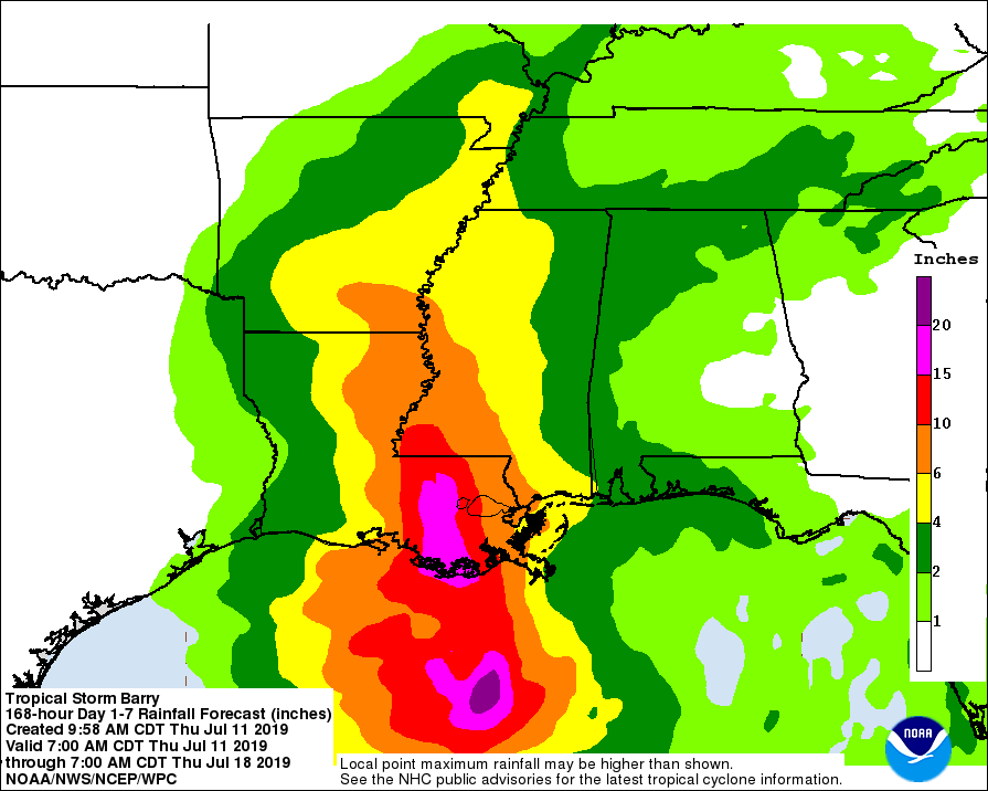
Things went downhill from that point, such that by late April there was talk of heavy rains impacting an already soggy southern Missouri and northern Arkansas! And the rains did come and they hit all over the central tier of states! Crops were lost, rivers became engorged and it was still relatively early in the spring season. Still, in my neck of the woods, it had been a relatively normal period of time (See graphic below).
Click on to expand
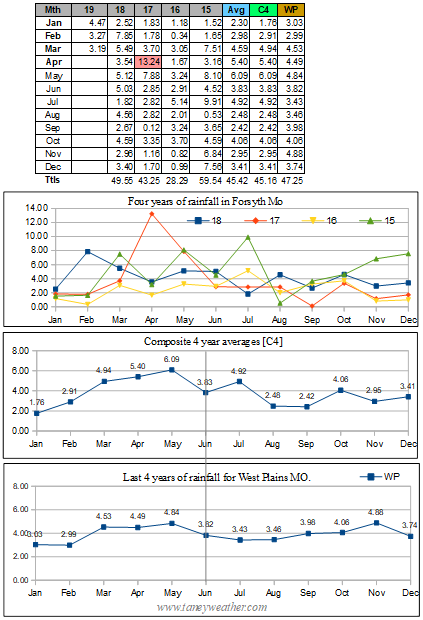
Rainfall was pretty normal and yet the water levels in the three large reservoirs (Beaver, Table Rock and Bull Shoals continue to rise). Then in mid May, things got rather nasty as tornado outbreaks became common for a short period of time!

Interestingly, my small town of Forsyth escaped 'most' of the storm action, even as its two parks (Shadowrock and River Run) began to submerge into the debts!

That brings us to mid June and yet another anomaly. If you look at the graphic showing the month's high and lows, it was very apparent that we were having quite the cool spell.

Click to expand

Wow! Four degrees below the thirty year average was pretty exception and it made me wonder what else 2019 would bring...


Thursday, May 23, 2019

Memorial Day forecast for 2019!

Taney County Mo. - Weather wise an upper level ridge will be over the Taney County area Friday and Saturday which will help push the storm track up to our north and west. (Will have to watch the far northwestern portions of the forecast area which will be closer to the western edge of ridge). Storms may be able to make it into the far western parts of the forecast area on Friday and Saturday. Again if any storms can make it into the area a few strong to severe storms will be possible across east central Kansas and west central Missouri as instability increases across the area. The main risk will be large hail and damaging winds. So, that would leave us Taney County folks pretty much in the clear for towns and cities like Branson and Forsyth!

An upper level short wave trough will then likely spread across the entire area on Sunday and will help flatten that ridge some. Storms will be able to affect a little more of the area on Sunday, but may not be able to get all the way into southern Missouri. Again, that be good news!

Highs will warm into the 80's all weekend with lows remaining in the 60's each night through the weekend. So, light up those BBQ's, get outdoors and have some fun!

Wednesday, May 15, 2019

Saturday, May 18 could see severe weather!

Forsyth MO. - This from the NWS:

[On Saturday, surface backed winds ahead of a northeast lifting low will yield adequate directional shear ahead of the cold front. In addition, a favorable Gulf fetch will maintain a moisture- laden
air mass with dew points in the mid 60's.

All of these ingredients may lead to the development of discrete super cells across southwest Missouri Saturday evening into Sunday, with all modes of severe weather possible.

While it is easy to get excited and lost in the model data, it is important to note that America's RAOB network will not begin sampling this potential storm for another 36-48 hours. Thus, be cautious not to over-hype yet.

Monday and Tuesday also look active with severe weather possible, but the models will undoubtedly change between now and then...]

------------------------------

In general, broad scale or regional weather pattern setups do not often veer to far from the average as seen by the computer models. That said, I do plan to really focus my attention to the grids that will present themselves on Friday, May the  17th. I plan to then do a followup forecast...

 Update: May 16 - 'The convection which develops over western and central KS on Friday is expected to shift eastward and possibly into the forecast area late Friday night into Saturday morning. If this occurs, the severe risk for Saturday could be conditional on just how much clearing can take place along with the resulting instability that might develop during the day for redevelopment of new storms. Note, however, that shear looks to be sufficient as the upper low begins to pivot northeast over KS during the daytime Saturday. Very moist air will be across the area and convection will likely cause intense rainfall at the very least. This initial upper level wave should move east of the area by Sunday morning.

Meanwhile, a secondary upper level low will begin to push into northern CA on Sunday morning and into the Rockies Sunday night into Monday. Strong to severe convection will again be possible
across the central and southern plains Monday into Tuesday, more likely Monday night into Tuesday across the CWA. Combined, these two systems are expected to bring around 2 to 5 inches of rain
across the area through next Tuesday, which will probably bring about some more flooding to the region.'

Also, see this article.... Apparently some others also feel this could be a big deal!


May 17 - 'Saturday (May 18) looks very active as showers and thunderstorms develop across the region. Severe thunderstorms are likely, while chances for excessive rainfall are increasing as well. Precipitable water values will run around 1.5 to 2 standard deviations above normal in an area with large scale ascent for several hours over the four state area.'

That was the latest from the NWS and the way I took it was to assumes that all forms of nastiness were still on the table.

May 18 - 'We will not be issuing a flood watch, since trying to pinpoint any areas that will receive excessive rain is proving to be difficult at this time. Therefore we utilized a super blend approach in populating the rainfall forecasts. However, I will say there are multiple models picking up on high rainfall rates, suggesting that localized amounts of over 3 inches will be possible through tonight.

There will also be a risk for severe weather, with all modes possible. Utilizing a RAP environment/HRRR convective prog statistical approach in forecasting short term severe weather, we
could receive a very busy episode of severe storms this afternoon. The longer the storms take to arrive, the more unstable the atmosphere will get, which will create a more volatile environment.' [Some wording paraphrased].

10:00 AM - Tornado Watch #182 issued for Taney County!

Aftermath: The storm front hit hard and fast at about 4:30 PM. Some area damage resulted along with power outages at my location as well as areas along Highway Y in Forsyth MO. Sadly, my anemometer was knocked out which forced me to order a replacement. Total rain at my station was .54 inches.


www.taneyweather.com

Monday, May 13, 2019

Anemometer down, sort of!

Forsyth MO. - My anemometer and wind direction instruments were relocated as work was being done on my 4th floor condo railing. Using what I had on hand, I jury rigged a temporary stand  and so my wind and wind direction reading my be a bit off for the next week or so.

Working on the balcony with no railing was an 'interesting' experience. www.taneyweather.com

Friday, May 10, 2019

Park flood watch 2019 and a possible solution!

Old pic (2017) of past flood of Bulls Shoals by Shadowrock Park
Forsyth MO. - Once again I was destined to sadly watch two area parks flood out. In general this had been happening about every two years or so. And, if you look at the rainfall data I had compiled at right, you can see that even on semi-normal year of rainfall, the parks could still become inundated. So what gives?

Bull Shoals Dam
Part of the problem lies within the state of Arkansas. Whenever that region gets above average rates of rainfall, we here in southwest Missouri will suffer as the Corps of Engineers are often forced to restrict the Bull Shoals dam (located in NE Arkansas) release rates.This creates a situation similar to what the kids did by building a cofferdam in the barrens in the Stephen King novel 'It'. Their actions caused all the sewage in the town of Derry Maine to back up and what a mess that was! That sort of describes what occurs whenever that dam in Arkansas cannot release enough water. The entire Bull Shoals reservoir backs up and large scale flooding results.

Canal in California
What exacerbates the problem, even more so, is the upstream reservoirs of Beaver and Table-Rock lakes which, when above full pools, feed the excess water into the 13 mile stretch of Taneycomo lake when then overflows the Powersite Dam on into Bull Shoals which then floods out valuable real estate. In my limited view, this entire string of reservoirs and dams was poorly thought out starting back in the 50's when the dams were constructed.Yet, perhaps, that was all that could be done at the time...

So what might be one possible solution? My thought was to obtain Federal funding for the construction of a canal, similar to what is commonly seen in California, that could run straight down to the Gulf of Mexico! Such an effort would cost billions of dollars, but could also act as a 450 mile long reservoir that could have mini hydro electric generators installed along it route to supply electricity to the towns and cities that were impacted by its construction. This could be a win-win situation for that entire region of the Central United States.

Wednesday, May 1, 2019

Storms batter SW Missouri on last day of April!

Forsyth MO. - And just like that two popular area parks near Forsyth were closed. Shadowrock and River Run Parks both look like they will visiting Davy Jones locker, yet again, as climate change begins to make itself felt everywhere!

Friday, April 26, 2019

Will River Run flood out - Part II?

May 2017 Powersite Dam
I paraphrased a National Weather Service forecast of potential doom that was published on April the 26, 2019 to read as follows:

A weather pattern change continues into early next week, setting the stage for a potentially very active week. Medium range computer models continue to advertise increasing low level moisture, southwest flow aloft and a meandering surface boundary near the Taney County area. This will likely result in periods of heavy rain along with the potential for several bouts of severe weather. However, details are still sketchy this far out, and certainly later forecasts need to be monitored as we head through the weekend.

With all three Tri-Lake reservoirs currently at, or above full pool levels, any episodes of heavy rainfall could result in the rapid flooding of parts of Lake Taneycomo (on a temporary basis) and all of Bull Shoals in the long term. Just how the scenario of storms will play out, the exact amounts and locations will greatly affect how severe flooding problems could become. 

It was my belief that the weather should begin to get interesting on or about Wednesday, May 1st. At right is a graphic showing water levels for all three reservoirs. I was guessing that part of the problem was with a restricted rate of flow at the Bull Shoals dam on the Arkansas border. This likely due to the Mississippi River setting record levels! And, since that problem isn't going to go away very soon, I felt that the survival of my two favorite parks; Shadowrock and River Run, would be entirely dependent on how much rain actually fell in the first week of May.

701.48 04-26-2019   12:45 CDT
So, only time will tell... At right Powersite Dam was releasing water on April 26, 2019.

Update: April 27 - The baroclinic zone then meanders near the area from Monday though Thursday as upper flow becomes more southwesterly. As has been previously mentioned, this set up is conducive to periodic showers and thunderstorms with heavy rain potential along with the potential for some strong to severe storms. The most impactful period looks to be Monday night through Tuesday night as a shortwave lifts out of the desert southwest and traverses the area. A corridor of precipitable water values of 1.50" to 1.75" feeding into the boundary with likely result in heavy rainfall.

At right is an animation of flood and high flow conditions for national rivers and streams. Note the condition of the mid parts of the Mississippi river system. That heavy load of flood waters will be making its way down to rivers that help drain the Tri-Lakes as we progress into early May. In my opinion, this could spell trouble for parts of southwest Missouri.

Update: Right on schedule, a massive system arrived on the last day of April to unload 2 to 3 inches of rain all across the region with more to come as we entered bravely into May. That will pretty much seal the fate of the two parks to a watery grave for 2019. Pics to come!

Friday, April 12, 2019

Heavy rains set for Saturday, April 13!

Forsyth MO. - An active weather pattern looked posed to invade the Midwest with heavy rainfall set to impact much of southern Missouri and all of Arkansas!

Precipatible water amounts of 1 to 2 inches looked to fall on the watershed that surrounds the Tri-Lake set of reservoirs which are comprised of Beaver, Table Rock and Bull Shoals lakes. Fortunately, all three bodies of waters were at or below normal full pool levels. And before anyone asks is this had been a cold or warm start to spring, I can say that we are about 5.5 degrees abov ethe 30 year average! www.taneyweather.com