Forsyth MO - On a slow day in October, I decided to look at the month of November and how the temperatures shaped up over the past five years! I specifically wanted to see what the average high and low for each day would look like when graphed out! Here's what I got in the way of a graph:
Here is the raw data:
What struck me was how consistent the 13th of that month had been for all those years - as in consistently cold! So, I thought it would be fun to see what happens this year!
Showing posts with label Forsyth Missouri. Show all posts
Monday, October 23, 2017
Monday, July 3, 2017
Taney County week of the fourth of July!
MONDAY
I think Monday will be mix of clouds
and sun to the north with generally cloudy conditions expected closer
to Arkansas. Best rain chances similar to yesterday will reside along
the Arkansas border
and portions of far southeast Kansas
and southwest Missouri later this afternoon and overnight. Lake of
The Ozarks region has the lesser rain chances, at least through the
short term period, though a rogue shower or storm can't be ruled out
across central MO. No widespread severe weather is anticipated at
this time due to marginal shear, however, the stronger cells may
contain some strong gusty winds.
TUESDAY - Happy Fourth if July!!
A more well established mid-level
impulse/vort max will roll into our region, unfortunately right in
time for Independence Day festivities.
As the
vortex slowly slides eastward, we'll need to monitor not only a
threat for some strong thunderstorm winds, but also localized flash
flooding given the slow forward progression of the vort/short wave,
which may not fully move out of our area until Wednesday or even by
early Thursday.
As we head into Tuesday daytime and
evening, the threat for showers and thunderstorms will slowly spread
east and north across the Missouri Ozarks. The threat for severe
storms looks marginal, especially for fireworks celebrations in and around Taney county. Any severe threat
would be confined to line segments with a damaging wind threat.
WEDNESDAY
As the the trough finally clears, a
strong upper level ridge should spread east at least temporarily from
the Rockies. This should limit rainfall chances and increase
afternoon temperatures just a bit. Being on the eastern side of this
high, northwesterly flow will still be over our region. Guidance does
swing a few minor impulses down our way from the northern plains,
which should cause at least a subtle increase in diurnally driven
showers/storms. This may also keep temperatures in the middle and upper 80's vs the lower 90's.
THURSDAY & Onward
THURSDAY & Onward
We should then get a break in the
action on Thursday with at least a low-end chance for storms
returning on Friday as a front approaches from the north. Global
models then insist on a northwesterly flow aloft becoming more
amplified from this weekend into early next week. This would support
that front moving south into the Missouri Ozarks, or perhaps even
south of the area into Oklahoma and Arkansas. Ultimately, the
position of this front will dictate precipitation chances. At this
point, we have kept PoPs in the 20-30% range from this weekend into
early next week.
Temperatures should return to near
normal values towards the tail end of this abbreviated work week
before we again see a slight cooling trend with the arrival of that
front this weekend.
Tuesday, February 23, 2016
Winter storm system slated to just graze the Forsyth MO area!
Forsyth MO – The weather scenario,
while not set in concrete, was coming more into focus...
Beginning Tuesday night (Feb 23) – an area of low pressure will traverse just to the south and east of Forsyth MO. Warm air aloft with some forcing ability will likely keep this a mostly all rain event through the evening hours with a gradual transition to snow, first occurring in the higher elevations and the spreading over south central and eastern Missouri as we go through the overnight hours. Even with the warm ground, the feeling was that there could be some bands of snow heavy enough (aided by gusty winds) to perhaps briefly cause travel conditions in the early morning hours of Wednesday. See www.taneyservices.com for more!
Thursday, June 5, 2014
Is the drought over? Will Bull Shoals flood?
Is the local area drought ending? Will River Run Park flood again? Two very good questions. As my readers may know, much of the south central and western states have been locked in a severe drought over the past couple of years. And, while Taney County in Missouri, where I reside, is nowhere near as bad as some parts of Texas and Oklahoma, concern is still evident by many.
However, rainfall over the past month
of May and now early on in June, has been encouraging. We seem (and I
use that word sparingly) to be transitioning into a wetter regime.
Let's take a look at some recent rainfall figures for Forsyth and West
Plains Missouri. See spreadsheet at right. The June figure was as of June the 4th. On the morning of the 5th, we received 1.01 inches here in Forsyth (no data yet for West Plains). This would bring our yearly total to 14.92 inches which would still put us 8.74 inches behind the average with the better part of a month yet to go to make up the difference! This graph which shows rainfall amounts versus the average through June clearly illustrates that the Forsyth are is on a Finally, a quick peak at Bull Shoals river levels as compared to 2011 when the entire River Run and Shadowrock Parks area were flooded all summer, you can see that while the levels are elevated, they would still have a ways to go to reach those levels!
Having made those statements, I always feel it's better to have a little more water than not enough. If the parks flood, then they flood as after all, they are designated flood plains. The next thirty days will more than likely tell the tale as to how this summer is going to proceed!
Track the weather in Taney County Missouri in real time at www.taneyservices.com!
Disclaimer: Every effort is made by the author to insure the figure supplied in this post are accurate. If and error was made, please contact him at Forsythkid@Gmail.com!
Track the weather in Taney County Missouri in real time at www.taneyservices.com!
Disclaimer: Every effort is made by the author to insure the figure supplied in this post are accurate. If and error was made, please contact him at Forsythkid@Gmail.com!
Sunday, March 9, 2014
Monday, December 2, 2013
December 5th weather may be mixed!
The
first Thursday in December 2013 looks like it might get a bit
interesting as the national Weather Service does not have a good
handle on the precipitation types that may impact parts of southern
and southwestern Missouri. Depending on the exact nature and depth of
a 'warm nose' that will be draped over the border counties between
Missouri and Arkansas, there exists the possibility for ice
accumulations late Thursday, especially on elevated surfaces. At some
point, this dome of warm mid level air will get pushed to the south. And, at that time, any additional precipitation would then fall as snow. Let me see...snow over ice...not a good idea! That said, accumulating snow is still expected across the entire
area with the heaviest amounts falling from late Thursday into Friday morning.
The snow will then taper off from west to east Friday afternoon.
Bitterly cold temperatures will then
settle on in for Friday and the weekend with highs only in the mid to
upper 20's! Overnight, the mercury may bottom out somewhere in the
single digits and man, that will be pretty darn cold!!! But wait! Yet
another frontal system may come through the area on Sunday, and while
it isn't forecast to be as strong as the previous system, any
additional stuff that falls from the sky will be in the form of snow
and could add to the snow pack!
Anyway, a rather wintry start to the
month!
Monday, November 25, 2013
The weather outside is frightful, and it's still November!
With
Thanksgiving 2013 just around the corner, I thought it might be fun
to think a little about December and some weather trends of note.
One of the great
things about being an ordinary and non-professional person is the inability of most
everyone to hold me to account when I make my weather predictions!
While I'm certainly no expert, I am colorful! Way back in August, I
made some predictions about what I felt was to come for the winter
season of 2013-14. And, I think I mentioned that we might get some
'weird weather' in the form of ice, snow and even record cold. (For
their part, the weather service is calling for a rather dry, non
snowy and warmer than normal December and January). How boring!
Well, here it is,
late November and already some exposed surfaces have been 'exposed'
to ice! Close locations, like Arkansas just to our south, have also
experienced the bite of winter with much colder than normal
temperatures and even a little ice storm thrown in for good measure! Texas,
unfortunately, got clobbered with a storm that has left 8 dead as of
this post. So, yes, things are getting a little weird out there and
that weirdness is starting a bit early! Early and persistent cold
conditions across much of the Midwest have helped to set the stage for some potentially
exciting times later in the season! Stay tuned, as things may only go downhill from here...
Tuesday, August 6, 2013
Will area parks flood in the fall of 2013?
![]() |
| Water levels above 668' will insure some flooding |
After a couple of bouts of heavy
rainfall early on in August, a couple of people inquired as to the
possibility of some flooding occurring in either River Run or Shadow
Rock Park. These two, side by side, parks are popular spots for
campers and RV'ers who visit the Forsyth area in here in southwest
Missouri. This year has seen a steady stream of vacationers with the
best of the fall season yet to come.
Now, as I do not proclaim to be any
sort of meteorological or hydrological expert, my opinions carry
little if any (ahem) water. But, living right next to the Bull Shoals
river way does give me a chance to view the water levels on a day to
day basis. And, this year, close to and slightly above normal
rainfall has lead to water levels that have hovered at or near the
665 foot mark with 654 feet being the lower limit of the so-called
'flood pool'; a target level which the Corps of Engineers strives
for. The above graphic shows, we've been above that level for most of
the summer. Now, what with all the rainfall across the much of the southern
portion of the state, these levels are sure to rise over the next
week or so. A situation that would only be exacerbated if more rain
does fall as predicted by the weather service.
| Boat launch at River Run Park |
The bottom line, in my opinion, is that
we stand a good chance of seeing some flooding of the River Run side
with little or no flooding of Shadow Rock Park.
Sunday, August 11 Update: The water level at Bull Shoals hit 664.60 feet this morning and as you can see some of the lower parts of the park are just beginning to flood. I'm guessing that no real problems will be encountered until the level hits and surpasses the 670 foot mark. At the current rate of water level rise (.82' per day) that would be on or about the August the 18th.
Thursday, February 21, 2013
The ice storm that really wasn’t!
When I were to think about all the really bad
possibilities this latest winter storm presented, I'm very thankful for all that it was not.
Promptly, at 6 AM this morning, I was wakened from a sound
slumber by a crack of thunder just outside my window. Shortly afterwards the
skies opened up and honest to goodness thunder ice was falling all about my
house located near Forsyth Missouri.
(Had this persisted more than a few minutes it would been a true disaster as
very quickly every surface was covered with a sheen of ‘lumpy’ ice, or more
technically, a form of sleet called graupel)! Thankfully, a dry slot appeared and gave the area a nice reprieve from about six to nine AM.
At 9 AM, I ventured outside to check on the street in
front of my home and found it to still be ice covered. A radio station, KRZK, earlier
informed me that most of the main roads were clear and that was a comforting
thought. So, even with a strong wind coming out of the east, I felt that
perhaps the worst of this storm was over and done…. and then I heard more thunder!
By 10 AM, the skies were once again becoming dark, or at
least darker than they had been a short time before. The mercury which had been
slowly climbing had also started to slide downwards a bit and a glance at the
local radar was not very re-assuring. (Even the radar was slower than normal to
refresh – a hint that a lot of people were accessing the same site).
At 9:56 AM a hard shower of sleet came through
and then quickly tapered of to a light drizzle of ice. I reflected that it was actually good thing that the air outside was cold enough so that we were getting ice
rather than freezing rain at that time!
This pattern of on again off again precipitation was to be repeated for the rest of the morning, depositing just enough sleet and freezing rain to keep the secondary roads in my area ice covered! Chatter from a police scanner located close by also informed me that the roads were pretty much free of civilian vehicles - a sign that most everyone heeded the warnings that had been posted earlier.
So passes our first real winter storm of the season. Now, if it would just warm up enough on Thursday to melt all this stuff, I'd be a happy camper!
This pattern of on again off again precipitation was to be repeated for the rest of the morning, depositing just enough sleet and freezing rain to keep the secondary roads in my area ice covered! Chatter from a police scanner located close by also informed me that the roads were pretty much free of civilian vehicles - a sign that most everyone heeded the warnings that had been posted earlier.
So passes our first real winter storm of the season. Now, if it would just warm up enough on Thursday to melt all this stuff, I'd be a happy camper!
Tuesday, February 19, 2013
Feb 20th will be a toss of the Wx Dice!
While God may not play dice with the universe, Mother Nature
can gamble with the best of em!
The National Weather Service, bless them, is not about to get
caught with another busted forecast as has so often been the case this winter.
No sir! This time they’re throwing in everything but the proverbial kitchen
sink when describing the winter storm that is due to impact the Forsyth are
sometime overnight on Wednesday, February the 20th!
As of this posting, the factors coming into play on that day are both
complex and problematic! While the weather prognosticators are pretty sure that
some wet stuff will fall all across the area, they seem to be at loss to say exactly what
form it will take. My bet is on all snow beginning late in the evening with a
slow transition to sleet and then ice in the early morning hours of Thursday. (Having
said that, this could be just another all rain event this far to the south with
all the interesting stuff happening way up by Springfield).
Whatever may happen, I’d personally advise anyone who normally travels
anytime between late Wednesday and overnight Thursday to call in sick, drink a
glass of warm milk and then pull the covers back over your head and stay in bed for the duration.
Monday, July 9, 2012
July 2012: the first week!
After literally baking in 100 plus heat for all of the first
week of July, we got some rain on the eight. Now, the new regime appears it
could be both high heat coupled with high humidity! Sometimes it seems you just
can’t win.
Currently, the total rainfall stands at .84 of an inch (the
average is 3.15 for the month) with only a hope of more to come in the form of
popup showers. Other than a very weak frontal boundary that barely moves, there
has been nothing in the way of an organized front to get the atmosphere
percolating once again.
Thankfully, the water that did deign to fall (.04 on
Saturday the 7th and .80 on the 8th), has done a lot to
perk up both the lawns and the trees in my area. While it may be hard to see so
early on, these three pictures show a marked improvement in the color of the
grass which had been almost all brown.
One thing that appears to be for sure; the temperatures are
trending upwards possibly in response to climate change. A change that may be
accelerating. Each day of the first week averaged out to 104F. Even more
disturbing was how warm the overnight periods were averaging at just under the
70 degree mark. The normal average has been 65 over the past thirty years! This
trend, should it stick, will bode poorly.
Saturday, February 11, 2012
An arctic invasion - Feb 10 - Day 1
![]() |
| Darkness settles in on a clear Feb evening! Wait! Up there in the corner! Is that Uranus? |
'It seems to me that just about all
winter long we've been spared harsh temperatures here in North
America while the folks living in Europe have been getting it dished
out to them big time! But, are we overdue for a change in the climate
guard?' Well, time will tell...
The weather service is forecasting for two events over the next couple of days; a blast of honest to goodness arctic air from the North Pole and wintry precipitation, most likely in the form of sleet or freezing rain. Should make for an interesting time, if you're a weather nut like myself!
The Arctic Express!
Right on cue, and in line with the National Weather Service forecast, we had an arctic front slam its way past my little southwestern Missouri town of Forsyth in the early afternoon hours of Friday, February the 10th. (You can most always tell when a front has a pant-load of cold air by the speed at which it makes it from the Canadian border to my front porch)! Starting at 2:30 PM, I kept an 'ad-hoc spreadsheet' which produced the graph seen below. The winds, which accompanied the front, picked up out of the north and were relatively constant from that point on until Saturday morning when they had calmed down just a bit. The average speed was about 5-7 mph with gusts to 13!
Shortly after six pm, the downward temperature
spiral hit the freezing mark and then continued creeping on down. (Not sure why there was an hour long pause in the trend just prior, however). About this
time, dusk was falling and the sky which had been overcast, cleared!
(Not very good signs as they indicated some 'radiational cooling' might
occur as a result). Sure enough, by 1AM we were flirting with 19°F.
and the rate of temperature loss was at about 1°
degree Fahrenheit per hour.
The next morning dawned partly cloudy
and very cold at just 14°F above zero
by 7AM. Those pesky arctic winds were also still in play, coming
resolutely out of the north (abet more slowly). Mornings like this reminded me of living in Chicago when it
got so cold your hands would stick to the car door handle! So, this was not a day
I'd normally want to venture out, but I did anyway. I wanted to go have
breakfast at a local eatery, so I bundled myself up, got into my Jeep
and made the trek into town. I'll tell you right now, it felt
every bit as cold as I imagined it would!
Hot food is the order of the day!
![]() |
| Hey! A man's gotta eat! Right? |
Back out on the streets, the traffic
was light. Typical for an early weekend. I got home, in short order,
and checked my gauges to find the temperature had gotten all the way
up to 16°F!
Gonna be a hot one, I thought! Well, at least I'll have time to run to the grocery store and stock up today before things get really nasty on Sunday.
[end
of day 1]
Wednesday, February 8, 2012
A hobbled together spring 2012 weather forecast!
After looking through some of the
technical jargon from the National Weather Service, I was able to
come up with a few snippets of information concerning the educated
'guessing' that will make up part of the long range forecast for
North America this coming spring and summer.
Two of the large driving forces for
weather, the ENSO or El Nina Southern Oscillation and the AO or
Arctic Oscillation seem to be change dynamically as we head into
early spring. While we have been living under the effects of La Nina
for some time now, that appears to be weakening. This may have the
effect of bringing wetter conditions along the northwest and
northeastern coasts while dryer conditions will prevail across much
of the south.
In addition the Arctic Oscillation
which had been strongly negative the past two winters has shifted to
positive earlier this winter and the trend of warmer weather for the
states should then continue. Just these two factors along would imply
that southwest Missouri can expect to see dry, but warmer than normal
conditions as we head into the spring months.
I'm not sure if anything has been
released officially at this point and want to remind my readers that
I am not a meteorologist.
Sunday, January 15, 2012
Weather Summary for first half of January 2012 in Taney County!
Flying on past me like a freight
train.
Boxcars repeat and flash before my eyes
In cyclical patterns that none could
denigh
Telling a tale of warmth followed by
cold
As high follows low, a story unfolds.”
And that poor attempt at a rhyme pretty
much sums up the zonal flow pattern that has been our weather
here, not only in southwest Missouri, but across the Nation. The
fronts have come through pretty much from west to east, never seeming
to stay very long. As a result, even though there have been a few
cold spells, they haven't lasted more than a few days before another
warmup builds in behind them. Not that I'm complaining, mind you!
The first two weeks of January have
certainly followed this see saw pattern, as you can see in the graph
of temperature highs and lows. And, because the incursions of cold
Canadian air have had limited opportunities, it's also been a rather
warm two weeks. The average or mean temperature has been 6
degrees above the historical average. That's huge! That fact combined
with the lack of snow across much of the country is unusual and has
me guessing again about global warming.
It has also been a dry two week period
with only just about an inch of rain. Traditionally, we will have
over three inches for the month, so there is also some concern over
the deficit. Everyone, especially the farmers, are concerned as to
the possibility of drought conditions as we head on into late winter.
I know that in Texas, this is a major concern, so everyone is
watching the skies these days.
Friday, December 16, 2011
Winter weather more likely now on Monday Dec 19
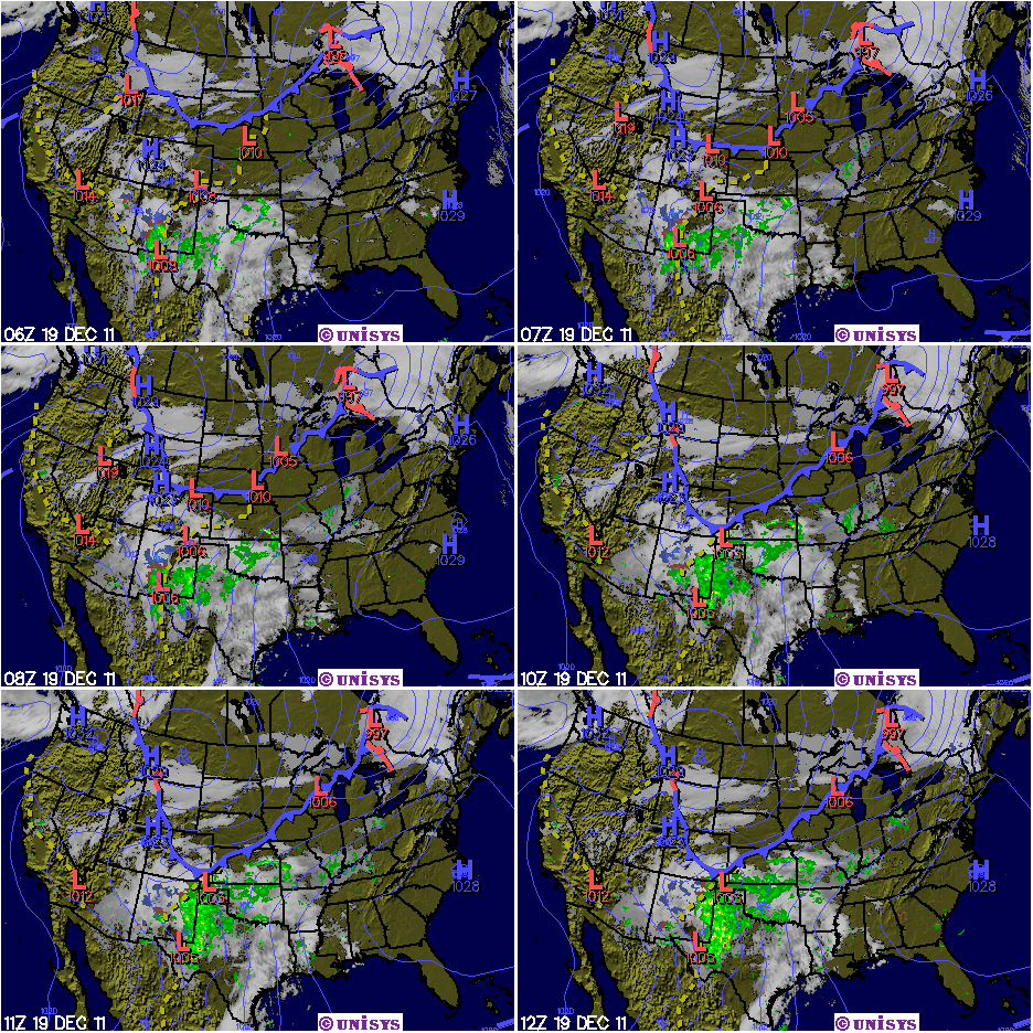
After looking at some of the grids and after making some wild guesses, I think there is an increasing likelihood for snow or sleet or ice to impact portions of southwest Missouri as early as Monday evening, December the 19th. While the exact track and type of precipitation at still up in the air, the odds are that Missouri locations along a belt extending from a Cassville to Salem line will be battleground central.
Whether or not this will pan out is anybodies guess. But, it will be fun tracking the low pressure system coming out of the Baja region of California beginning sometime over the coming weekend.
Following is some of the latest professional discussion from the NWS:
“As it stand right now...a track from Cassville to Salem would yield a period of rain on Monday and on Monday night...with precipitation changing to snow as cold air streams in behind the surface low and a well developed 'TROWAL*' structure moves over much of Missouri.
Obviously...the surface track will likely change from its current depiction in the computer "Model World"...and even just a small change either north or south will cause a drastic change on thermal profiles and the precipitation type...as well as surface temperatures and thus any wintry precipitation accumulations.”
*Trough of Warm Air ALoft. Typically used during winter weather, it is a "tongue" of relatively warm/moist air aloft that wraps around to the north and west of a mature cyclone. It is best analyzed between 750-550 milibars using equivalent potential temperature (theta-e). Areas of intense lift and frontogenesis are commonly associated with TROWALs, hence they are favored regions for heavy and/or prolonged precipitation. During a winter storm, the heaviest snowfall amounts frequently occur along and north of the TROWAL axis.
December 18 followup: Still looking good for some snow to impact the I-44 corridor by late Tuesday or early Wednesday. Heaviest snow looks to be in Texas panhandle region at this time.
December 19 followup: It now looks as though parts of AZ and NM will get his with lots of snow with blizzard conditions possible is some areas. Also impacted, at this time will be parts of western Kansas. The forecasted northerly track of this storm would seem to indicate that southwest Missouri will miss out on much of the wintry action settling instead for a mostly rain event.
December 20 followup: Now looking like the system of snow will pretty much miss Missouri entirely. Still, it did pack quite a punch in some of the states off to the west!
December 19 followup: It now looks as though parts of AZ and NM will get his with lots of snow with blizzard conditions possible is some areas. Also impacted, at this time will be parts of western Kansas. The forecasted northerly track of this storm would seem to indicate that southwest Missouri will miss out on much of the wintry action settling instead for a mostly rain event.
December 20 followup: Now looking like the system of snow will pretty much miss Missouri entirely. Still, it did pack quite a punch in some of the states off to the west!
Subscribe to:
Posts (Atom)