Thursday, May 23, 2019

Memorial Day forecast for 2019!

Taney County Mo. - Weather wise an upper level ridge will be over the Taney County area Friday and Saturday which will help push the storm track up to our north and west. (Will have to watch the far northwestern portions of the forecast area which will be closer to the western edge of ridge). Storms may be able to make it into the far western parts of the forecast area on Friday and Saturday. Again if any storms can make it into the area a few strong to severe storms will be possible across east central Kansas and west central Missouri as instability increases across the area. The main risk will be large hail and damaging winds. So, that would leave us Taney County folks pretty much in the clear for towns and cities like Branson and Forsyth!

An upper level short wave trough will then likely spread across the entire area on Sunday and will help flatten that ridge some. Storms will be able to affect a little more of the area on Sunday, but may not be able to get all the way into southern Missouri. Again, that be good news!

Highs will warm into the 80's all weekend with lows remaining in the 60's each night through the weekend. So, light up those BBQ's, get outdoors and have some fun!

Wednesday, May 15, 2019

Saturday, May 18 could see severe weather!

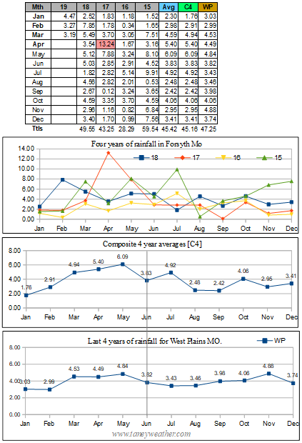
Forsyth MO. - This from the NWS:

[On Saturday, surface backed winds ahead of a northeast lifting low will yield adequate directional shear ahead of the cold front. In addition, a favorable Gulf fetch will maintain a moisture- laden
air mass with dew points in the mid 60's.

All of these ingredients may lead to the development of discrete super cells across southwest Missouri Saturday evening into Sunday, with all modes of severe weather possible.

While it is easy to get excited and lost in the model data, it is important to note that America's RAOB network will not begin sampling this potential storm for another 36-48 hours. Thus, be cautious not to over-hype yet.

Monday and Tuesday also look active with severe weather possible, but the models will undoubtedly change between now and then...]

------------------------------

In general, broad scale or regional weather pattern setups do not often veer to far from the average as seen by the computer models. That said, I do plan to really focus my attention to the grids that will present themselves on Friday, May the  17th. I plan to then do a followup forecast...

 Update: May 16 - 'The convection which develops over western and central KS on Friday is expected to shift eastward and possibly into the forecast area late Friday night into Saturday morning. If this occurs, the severe risk for Saturday could be conditional on just how much clearing can take place along with the resulting instability that might develop during the day for redevelopment of new storms. Note, however, that shear looks to be sufficient as the upper low begins to pivot northeast over KS during the daytime Saturday. Very moist air will be across the area and convection will likely cause intense rainfall at the very least. This initial upper level wave should move east of the area by Sunday morning.

Meanwhile, a secondary upper level low will begin to push into northern CA on Sunday morning and into the Rockies Sunday night into Monday. Strong to severe convection will again be possible
across the central and southern plains Monday into Tuesday, more likely Monday night into Tuesday across the CWA. Combined, these two systems are expected to bring around 2 to 5 inches of rain
across the area through next Tuesday, which will probably bring about some more flooding to the region.'

Also, see this article.... Apparently some others also feel this could be a big deal!


May 17 - 'Saturday (May 18) looks very active as showers and thunderstorms develop across the region. Severe thunderstorms are likely, while chances for excessive rainfall are increasing as well. Precipitable water values will run around 1.5 to 2 standard deviations above normal in an area with large scale ascent for several hours over the four state area.'

That was the latest from the NWS and the way I took it was to assumes that all forms of nastiness were still on the table.

May 18 - 'We will not be issuing a flood watch, since trying to pinpoint any areas that will receive excessive rain is proving to be difficult at this time. Therefore we utilized a super blend approach in populating the rainfall forecasts. However, I will say there are multiple models picking up on high rainfall rates, suggesting that localized amounts of over 3 inches will be possible through tonight.

There will also be a risk for severe weather, with all modes possible. Utilizing a RAP environment/HRRR convective prog statistical approach in forecasting short term severe weather, we
could receive a very busy episode of severe storms this afternoon. The longer the storms take to arrive, the more unstable the atmosphere will get, which will create a more volatile environment.' [Some wording paraphrased].

10:00 AM - Tornado Watch #182 issued for Taney County!

Aftermath: The storm front hit hard and fast at about 4:30 PM. Some area damage resulted along with power outages at my location as well as areas along Highway Y in Forsyth MO. Sadly, my anemometer was knocked out which forced me to order a replacement. Total rain at my station was .54 inches.


www.taneyweather.com

Monday, May 13, 2019

Anemometer down, sort of!

Forsyth MO. - My anemometer and wind direction instruments were relocated as work was being done on my 4th floor condo railing. Using what I had on hand, I jury rigged a temporary stand  and so my wind and wind direction reading my be a bit off for the next week or so.

Working on the balcony with no railing was an 'interesting' experience. www.taneyweather.com

Friday, May 10, 2019

Park flood watch 2019 and a possible solution!

Old pic (2017) of past flood of Bulls Shoals by Shadowrock Park
Forsyth MO. - Once again I was destined to sadly watch two area parks flood out. In general this had been happening about every two years or so. And, if you look at the rainfall data I had compiled at right, you can see that even on semi-normal year of rainfall, the parks could still become inundated. So what gives?

Bull Shoals Dam
Part of the problem lies within the state of Arkansas. Whenever that region gets above average rates of rainfall, we here in southwest Missouri will suffer as the Corps of Engineers are often forced to restrict the Bull Shoals dam (located in NE Arkansas) release rates.This creates a situation similar to what the kids did by building a cofferdam in the barrens in the Stephen King novel 'It'. Their actions caused all the sewage in the town of Derry Maine to back up and what a mess that was! That sort of describes what occurs whenever that dam in Arkansas cannot release enough water. The entire Bull Shoals reservoir backs up and large scale flooding results.

Canal in California
What exacerbates the problem, even more so, is the upstream reservoirs of Beaver and Table-Rock lakes which, when above full pools, feed the excess water into the 13 mile stretch of Taneycomo lake when then overflows the Powersite Dam on into Bull Shoals which then floods out valuable real estate. In my limited view, this entire string of reservoirs and dams was poorly thought out starting back in the 50's when the dams were constructed.Yet, perhaps, that was all that could be done at the time...

So what might be one possible solution? My thought was to obtain Federal funding for the construction of a canal, similar to what is commonly seen in California, that could run straight down to the Gulf of Mexico! Such an effort would cost billions of dollars, but could also act as a 450 mile long reservoir that could have mini hydro electric generators installed along it route to supply electricity to the towns and cities that were impacted by its construction. This could be a win-win situation for that entire region of the Central United States.

Wednesday, May 1, 2019

Storms batter SW Missouri on last day of April!

Forsyth MO. - And just like that two popular area parks near Forsyth were closed. Shadowrock and River Run Parks both look like they will visiting Davy Jones locker, yet again, as climate change begins to make itself felt everywhere!