Tuesday, March 16, 2021

Severe weather watch for Wed, Mar 17!


Hopefully, everyone living in southwest and the central parts of Missouri will have made sure their personal weather alert radios are checked and are on!

Wednesday, March 17, 2021 looks to be a likely day when portions of southern Missouri and northern Arkansas may see some potential develop for super cell development along with attendant chances for large hail and tornadoes.

I plan to be keeping tabs during the day on Wednesday and will be posting updates right here. Note that you can get real time data at my personal weather station (KMOFORSY5) located in Forsyth, Missouri! www.taneyweather.com

Friday, March 5, 2021

Unstalble weather for mid March 2021!

NWS - 'Overall looking at a more active pattern starting in the middle of next week (March 10). While details such as timing, moisture available, and system track are uncertain, the pattern is supportive of potential for thunderstorms, including the potential for strong to severe storms and flash flooding across portions of the central U.S. Again, it is too early to predict associated hazards across our area, so stay tuned to the forecast over the next few days.'

Last year, March 11th saw the start of a period of heavy rainfall that resulted in a month that saw 7.67 inches of rain at my location in Forsyth Mo. Very often, the last part of March can act a signal as to what trends can be expected as we enter into the 'wet months' of April and May.

Sunday, February 21, 2021

Spring 2021 weather outlook!

Despite Old Man Winter's fashionably late arrival, he made a no-holds-barred entrance. And AccuWeather forecasters are warning in the company's annual spring forecast, released this week, that the winter hits may keep on coming even well into spring for some regions.

It could be a long ride of wintry weather as the official start of spring is still about six weeks away. Astronomical spring officially begins at the equinox, which will occur at 5:37 AM EST on March 20, 2021, and nearly three weeks after the start of meteorological spring, which, year in and year out, starts on the first day of March.

Similar to the winter months, the overall weather pattern across North America will be influenced by a phenomenon known as La Niña. This is a phase during which the water near the equator of the Pacific Ocean is cooler than normal, which, in turn, affects the atmosphere. The effects in the U.S. from La Niña “could create a volatile situation" with an active severe weather season anticipated and more snow chances predicted across the northern tier.

“I agree with the AccuWeather experts,” Extreme Meteorologist Reed Timmer said during an AccuWeather Network special for Groundhog Day. “It’s going to be a late start to the severe weather season, but it’s going to be incredibly active. I think we’re going to be storm chasing a lot in April and May.”

Above statements were excerpted from www.accuweather.com.

Friday, February 19, 2021

Powersite dam March 22, 2020 March is a month where much southwest Missouri sees many climate associated changes. The azimuth of the sun arcs high and higher in the sky and the temperature regime changes rapidly from a winter style profile to a much warmer spring type feeling. It’s truly a month of rapid change! For 2021, I was hoping not to see a repeat of the year before. March 2020, not only saw extensive flooding in area parks, in and around Forsyth Missouri, but also that year witnessed the acceleration of the Covid virus. From a pure weather perspective, the month was relatively benign with an average temperature of 53.6°F versus the normal average of 45.5°. Where it did show an excess was in the amount of rain fall we had. I recorded a total of 7.67 inches versus a ‘normal’ for the month of 4.53” (I used date from the NWS site at West Plains, Mo for this).
River Run Park March 22, 2020. Bull Shoals at 669.25′ By the 19th of that month, water levels in Bull Shoals began to rise fairly rapidly. And, at first I wasn’t sure why that would be. After all a few extra inches of rain shouldn’t make that big of an impact, right? Sure, but for two facts that happened; 1) the upper of the three reservoirs, Beaver Lake was about seven feet higher than normal coming into the month and 2) rains that did fall generally impacted a very large cross section of southwest Missouri and northwest Arkansas. These two facts combined in a synergistic fashion to force the Corps of Engineers to begin releasing large amounts of water early on in the season (see photo at top). The question remain, for 2021, as to what will transpire. Note: All weather data was taken from my personal weather station located at www.taneyweather.com. Copies of the month of March 2020 are available by writing me at Forsythkid@gmail.com.

Thursday, February 11, 2021

Feb 13th weekend to be cold and snowy!


NWS (edited and paraphrased by this site) – A upper (frontal) wave that is currently situated over the central north Pacific will move onshore into the Pacific NW late Friday night then proceed to dig southeast into the southwest U.S. early this coming weekend. Guidance varies, but the mean/median guidance does point to an increasing chance for snow on Sunday and Monday. Hard to be too specific with amounts given where this system initialized, but there is a general agreement concerning the high potential for accumulating snow. System will run into a southwest to northeast baroclinic zone and southwest Missouri will be on the (very) cold side of the zone, with temperatures in the single digits and lower teens, during this time. Initially, precip may fight some dry air with a weaker first wave Sunday/Sunday night, but a second wave (potentially) will bring additional snow on Monday. [How’s that for hedging our bets!]

The forecast snow amounts for now will be inherently somewhat conservative given that it is a model blend. It does yield 3-5 inches from northwest to southeast over the CWFA or County Warning Forecast Area (official). Concerned that the NBM (National Blend of Models) snow ratios are too low, ran a quick snow forecast based on 50th percentile for snow ratio guidance (close to 20:1) which yielded snow amounts about 2-3 inches higher (unofficial). We will definitely need to keep an eye on this system. Given how cold it will be, snow ratios will be high and will easily accumulate on a very cold ground.

Tuesday, February 9, 2021


No matter how you slice up the day, Saturday the 13th of February, is going to pose a problem for many all over the central part of the the US.

Let me begin with the National Weather Services forecast:

‘By Thursday Feb 11, a reinforcing shot of cold air is expected to slowly filter into the region. This will keep daily highs in the lower to middle 20’s through the upcoming weekend. Cannot rule out highs in the upper teens across central Missouri. Overnight lows through the upcoming weekend will fall into the single digits to lower teens. Add in a light wind and wind chill values will make it feel closer to zero or below. This prolonged period of much below normal temperatures could potentially hang on through the middle of February. However, it is worth noting that some model guidance has backed off a bit on how far south the very cold air mass digs in. This will be assessed in future forecasts.’

So, starting with Thursday, it’s going to get really cold outside. And the very frigid core of that arctic invasion will occur on or about Saturday. (Remember to keep an eye on your pets).

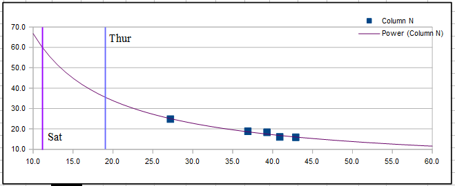
The above scatter chart (that was started on Feb 3) compares actual average temps versus power used. It’s a neat tool that can allow one to predict power demands in the future based on what has happened in the past. (The red line is a power trend line to help with the visualization). Note that on Saturday, with a projected Hi of 21° and a Low of 0° the average temp for the day would be close to 11°. Then it’s easy to see that the purple line representing that average would indicate a power use of 60 kWh’s. That amount of power used would work out costing me ~ 60 kWh * 1.2535/kWh (Liberty Utility rate) = ~$8 for just that one day!

The hope is that this bolus of cold air will not penetrate as far southward as predicted. www.taneyweather.com

Tuesday, February 2, 2021

Southwest Missouri to experience a brutal cold wave!


According to my records, the last time, my small town of Forsyth Missouri, saw a string of really cold air was back in February of 2015!

Just to be fair, there have been days scattered here and there where I’d awake to temps in the teens. Sure. But, in general, a fast recovery was just around the corner. That’s not going to be the case, if the forecasts being put out by the National Weather Service is correct!

NWS statement –

'A true arctic front looks to drop into the area sometime during the day on Saturday. High temps will likely occur early in the day and then fall from there. We have not strayed too far from the mean of model guidance for temps this weekend. While there is still decent spread, there is a fairly strong signal that Sunday will be the coldest day with highs potentially remaining in the 20s, possibly colder. Low temperatures in the single digits to teens are also possible. Wind chills below zero are looking increasingly likely this weekend.'

If that statement is true, and if this sort of frigid nonsense were to go on from Saturday late (Feb 6) through Thursday, the 11th of the following work week…. Wow, that will be something to witness. Now here’s a word of caution. Best be prepared!

For a retired man, such as myself, I do know one thing for sure, I’m not likely to want to venture out very often, if the high on a particular day is only in the low thirties! So, in order to avoid that this time, I planned to visit my local grocery store, while it was still relatively warm. My motto, ‘when forewarned of chilly times, stock the shelves, perchance to hibernate, and slumber til better climes’!

For those with crawlspaces, it might be a good idea to check for any open vents as I failed to do years ago when it got very cold. Had I sealed them properly, I would have avoided an expensive plumbers bill!


Lastly, as the data above shows, cold spells that last more than a couple of days, can really cause one’s furnace to go into overload. My kilowatt hour use that February in 2015 was just over 1800 kWh’s. That translated to a whopping $234 electric bill for a man who had grown use to only about ninety dollars or so… Bummer.

But before I get too worked up. I plan to calm down, have a cup of coffee and wait for the very much more accurate update that will come along about next Thursday, Feb the 4th! Until then, I will be commenting on my weather site at www.taneyweather.com!

Friday, December 18, 2020

Cold weather for Taney County on Christmas!

God, please Bless America and Donald J. Trump!
 
Dec 22 - 
A cold arctic air mass will spill south out of northern Canada
Wednesday night into Thursday and make its way into the Ozarks
behind the cold front for Christmas Eve and Christmas Day. Highs
on Thursday will struggle into the 30's with lows Christmas morning
in the teens. The combination of temperatures in the teens and
winds from 5 to 15mph Christmas morning will allow some wind chill
readings to fall into the single digits for parts of the Ozarks,
especially the eastern Ozarks.

Tuesday, September 22, 2020

Weather forecast for 2020-21 winter!


 It was looking like it would be a tossup of the coin, as to whether we would have La Niña type weather - 'According to a recent report from NOAA’s Climate Prediction Center, there is a 50-55% chance of La Niña conditions arriving this fall and lasting throughout the winter of 2020-2021.

The map shown above is a pretty generic weather forecast with my neck of the woods, in southwest Missouri, being pretty average - A bit warmer than normal with little rainfall.

Sunday, July 12, 2020

First heat wave of 2020!

Forsyth MO. - Well, after an eventful spring and summer, I'm back! From where, I have no idea!

Southwest Missouri, along with much of the Midwest will get a small taste of a summer heat wave, beginning on Tuesday, July 14th. Surface temps look to reach the mid to upper 90's with heat indices reaching 100 plus! Additionally, no rain appears in the forecast at this time!

Tuesday, January 14, 2020

Some weather concerns for Thursday, Jan 16 2020!

Thursday will be cooler behind a cold front combined with clouds overhead. Expect highs from the upper 30's N to the mid 40's S.

The NWS was concerned about wintry precipitation chances Thursday night into Friday morning. Surface ridging shifts east while a shortwave trough and associated surface trough moves into the western Plains. This will lead to warm air advection over a shallow cold layer. The questions are: How warm is that warm nose, how cold is the near surface cold layer, and how much precipitation will actually fall?

Most models agree that the near surface cold layer will be near or below freezing over much of the area after evaporative cooling takes place. There is some disagreement in the extent and timing of the warm nose. Precipitation may start as snow and change to freezing rain later Thursday night or Friday morning, then switch to rain as surface temperatures increase later Friday morning. For now have gone middle of the road with consensus guidance for that warm nose, which gives some freezing rain and snow snow over the eastern half of the CWA (surface temperatures are currently forecast to be a bit too warm for freezing rain over the western half, but that will need to be fine tuned). While still a bit far out, it is helpful to look as some ensemble spread in amounts for a general overview.

Wednesday, January 8, 2020

Finally, some winter style weather!

Taney County, MO – It was looking like area residents in southwest Missouri might finally see some winter-styled action after enjoying temperatures that were pretty far above the normal, for this time of year! As it now stands, sometime on Friday, January the 10th, a strong frontal system will move into our area in conjunction with a robust up-welling of moist air from the gulf. The heaviest rainfall should occur from Friday afternoon on through the evening hours. At this time, the front will likely shift from west to east thereby crossing the country-wide area. As it passes on through. during the late evening hours, cold air will begin to push its way on the backside. Then, perhaps as we get into the wee hours of Saturday and on into the day, some southwest Missouri residents may expect potentially all forms of wintry precipitation; from cold rain, to freezing rain, to sleet, to grapnel and then to snow. Just who gets what will depend on where you happen to be standing, but I'd wager that most of Taney County will experience the event as one of moderate rain with a transition to some light snow late Saturday evening. Those living up further north by Springfield or off to the east by West Plains will likely get their own mix.

The real concern will be in just how much water falls where! With amounts ranging from perhaps a half inch to over four inches, everyone in flood prone areas needs to hang close to their weather radios or to televised media outlets throughout the day on Saturday. [www.taneyweather.com]

Saturday, November 30, 2019

Forecast for first week in December 2019!

Click to enlarge
Forsyth MO. - Wow! The first seven days in December are looking pretty good, considering the time of year!

Sunday looked to be somewhat windy as cold as we got the backside of an upper level low pressure system.

Monday and Tuesday were looking to be a bit raw in the temperature department with winds out of the north. Tuesday, however with see things warms a bit later in the day!

Wednesday was looking good! Possibly the pick of the litter!

A quick moving system will push across the southern plains into the mid and low Mississippi valley regions Thursday into Friday and will bring the next chance of precipitation to the area. Right now it looks like mostly rain showers for the area with the better instability for thunderstorms remaining to the south and colder air for winter precipitation to the north.

The Saturday, to start the weekend is also looking quiet with fairly normal temps!


Average temperature clothing protocols!

One simple tool I like to use when planning on what to wear involves the average temperature that is forecast for any one day. Averages are good for me to use in the sense that they can help me on what type of attire to consider wearing on any given day. For me there are five ranges to consider:

Average temperature range


Greater than 80F - Stay inside, it's too hot! Crank the AC!
70 - 80F - Shirtsleeves only type of weather
50-70F - Light Jackets in the afte3rnoon and evenings
40-50F - Jacket or a multi layered number of layers needed all the time
Less than 40F - Stay inside and hug a heater!

Liberty Utilities, a reall winner!

Forsyth MO. - While I'm not one to complain very often, after experiencing two power outages in 24 hours (both due to small area storms), I find myself getting more and more pissed off.

The outages were both brief, lasting less than a minute, but were sufficient to mess up some electronics I have running all the time. And, I was beginning to wonder if Canadian owned Liberty Utilities were really aware of what century they were in? Certainly not the 21st!

I've seen a trend, over the past year, of this company having a difficult time of servicing it's customers in a consistent manner. And, I was now wondering how well Taney County would fare when a really big storm system hit over the coming winter season?

Tuesday, November 26, 2019

I guess we could use the rainfall, but...

Forsyth Mo. - As we close out the month of November 2019, one observation I can make would be that the excess rainfall could be problematic for three area reservoirs, aka Beaver, Table Rock and Bull Shoals! Thanksgiving Day was to see a series of rounds of rainfall that could bring anywhere from 1 to 3 inches of precipitation that would place that month over the norm once again.

The question, then becomes whether or not enough water can be released via the Bull Shoals dam located in Arkansas prior to the typical spring rains we will get come next spring?

Thursday, November 14, 2019

A November 2019 look at Tri-Lake water levels!

Forsyth Mo. - As of mid November, 2019, water levels at all three reservoirs remained at uncomfortably high levels. And, I was wondering why that was happening?

Rainfall vs the historical averages from September thru mid November was as follows;


Assuming that the entire area gets 'normal' rainfall through the end of the month, one can see that we were only a little over four inches above normal. Yet, the lake levels remained way above normal levels!

Friday, November 1, 2019

November 2018 was not nice!

Forsyth Mo. Did November have much to recommend in 2018, actually no. It was colder than normal on many days, as the graphic of the daily average temperatures below shows.


Thursday, October 31, 2019

October 2019 was pretty near normal!

Forsyth MO. - Even as I did not wait for the 31st reading, the trend line for the month showing a drop of 21°F was pretty much set in stone. That line was pretty close to the 70/44 spread that is the 30 year historical average for neighboring West Plains. My area showed a 69/49 spread which also reflected the typically higher reading seen during the nighttime hours.

Tuesday, October 29, 2019

Things could become a bit dicy toards the end of Nov 2019!

NWS, Springfield MO - An upper level trough will start to move east across the central Plains on Wednesday then through the area on Thursday. Lift will continue to occur ahead of the system resulting in periods of rain occurring across the area at times on Wednesday. The warm nose will remain in place through the day on Wednesday as temperatures remain above freezing. Highs will top out in the upper 30's to the upper 40's across the area Wednesday with the warmest readings across south central Missouri.

As the upper level trough starts to move into the area, surface temperatures will start to drop from northwest to southeast Wednesday evening and night. A dry slot will move into the area associated with the upper level trough. Drizzle will occur across the area as the dry slot will limit cloud ice. Temperatures will drop to or just below the freezing mark as lift and low level moisture remain in place Wednesday evening and night. This will result in a window for some freezing drizzle to occur mainly across the northern and western parts of the forecast area. Ground temperatures are still warm so not expecting a lot of impacts, but a light glaze of ice could be possible on elevated surfaces so take care when crossing bridges. As the upper level trough moves through the area mid level moisture will wrap into the area as mid level temperatures cool. This will allow for some light snow to occur late Wednesday night into Thursday before the precipitation comes to an end from west to east on Thursday. Minor if any accumulations and no real impacts are expected.

Widespread rainfall will occur across the area with generally 1 to 1 1/2" of rainfall expected for the entire event. Portions of south central Missouri may see closer to 2". Rates are not expected to be overly heavy at any given time, but widespread to moderate rainfall will occur for an extended period starting late this afternoon into Wednesday night. This may lead to the potential for some localized minor flooding as this widespread rainfall occurs.

Behind the system surface high pressure and a colder air mass will move over the area. Lows in the mid to upper 20's are expected Wednesday night with highs only warming into the 30's on Thursday. Lows Thursday night into Friday will drop into the low to middle 20's. Temperatures will then warm back into the 40's and 50's for highs Friday into the weekend.