

Showing posts with label 2019. Show all posts
Showing posts with label 2019. Show all posts
Thursday, October 31, 2019
October 2019 was pretty near normal!

Saturday, October 26, 2019
Snow in October

Staggering differences in model solutions remain during the
Tuesday through Friday time frame, but all global models indicate a
strong surge of cold air between Wednesday and Thursday. Thus,
that will be the message of the forecast; and not the potential
for measurable snow. The GFS remains the most progressive with
the upper-level shortwave and the surge of cold air, as a
TROWAL/deformation axis develops over central Missouri
Wednesday/Thursday with banded measurable snow. On the other hand,
the CMC and ECMWF offer much slower solutions with the upper-
level pattern, suggesting a warm and rainy Wednesday/Thursday.
These latter models then bring the cold air in Thursday/Friday
with a prevalent dry slot, thus, limiting snow chances.

For now, we have gone with our model blend for temperatures and
precip type from Tuesday to Friday. Temperatures Tuesday and
Wednesday will exhibit highs in the 40s and lows in the 30's.
Then, Thursday and Friday will feature highs in the 40's and lows
in the 20s. Right now, we aren't mentioning more than a 0.5" of
snow across our area for next week.
 Whatever does happen, it looks like many of us, living in Taney County Missouri, will be getting a does of some winter like temperatures. A trend that looks to continue right on into early November....
Here's the forecast map for Monday, Oct 28 - That don't look very good to me...

Monday, August 12, 2019
High temps may cause electrical outages!

After experiencing an outage on Friday, July 19 that lasted for a number of hours, I received this email test after complaining to Liberty Utilities (see post entitled July 19 power Outage:
'Unfortunately we cannot promise service 24/7 but when we do experience an outage we respond as quickly and safely as possible. We did have and issue with a substation, we can’t predict when this might happen however with the extremely high heat index we have experienced that may cause extra load on our equipment. With our lineman responding quickly and our customers conserving usage we will do our best to make sure outages are as infrequent as possible.'
The admission that high heat indices, like the 110 degree one expected on this date (August 12, 2019), lead me to issue my very first prediction....
'Look for numerous and widespread power outages all across southwest Missouri to occur as outdated and insufficient power grid resources are anticipated to fail under the increased load caused by so many AC units running like mad.'
That is my prediction in the early morning hours of the day. I'll sit back as now watch to see what occurs....
Tuesday, July 9, 2019
Tropical depression likely to form in the Gulf!

NHC: There is a high probability (80%) that a tropical depression is likely
to form by the end of the week over the northern Gulf of Mexico. This
system also has the potential to produce heavy rainfall along portions
of the northern and eastern U.S. Gulf Coast later this week.
--------------------------------------
My thoughts: An early and
active hurricane season could perhaps spell trouble for the Tri-Lakes group
of reservoirs in southwestern Missouri should such a tropical depression ever happen to impact the Gulf of Mexico
region, in my opinion. Such systems can sometimes (rarely?) act as a moisture pump that can bring heavier than normal
rains to the Central North American states!
Table
Rock Lake was currently at 921 feet with a flood pool set at 931'. If water
levels were to get that high, the Corps of Engineers would be forced
to open the ten Tainter gates two and a half feet allowing 150,000
cubic feet per second of water to be released into Taneycomo
which would not be able to hold back any water due to a
damaged air bladder mechanism. Such an event could pose problems further downstream. [Note: Repeated attempts to contact the Corps had failed to elicit any useful information concerning repair time estimates.]
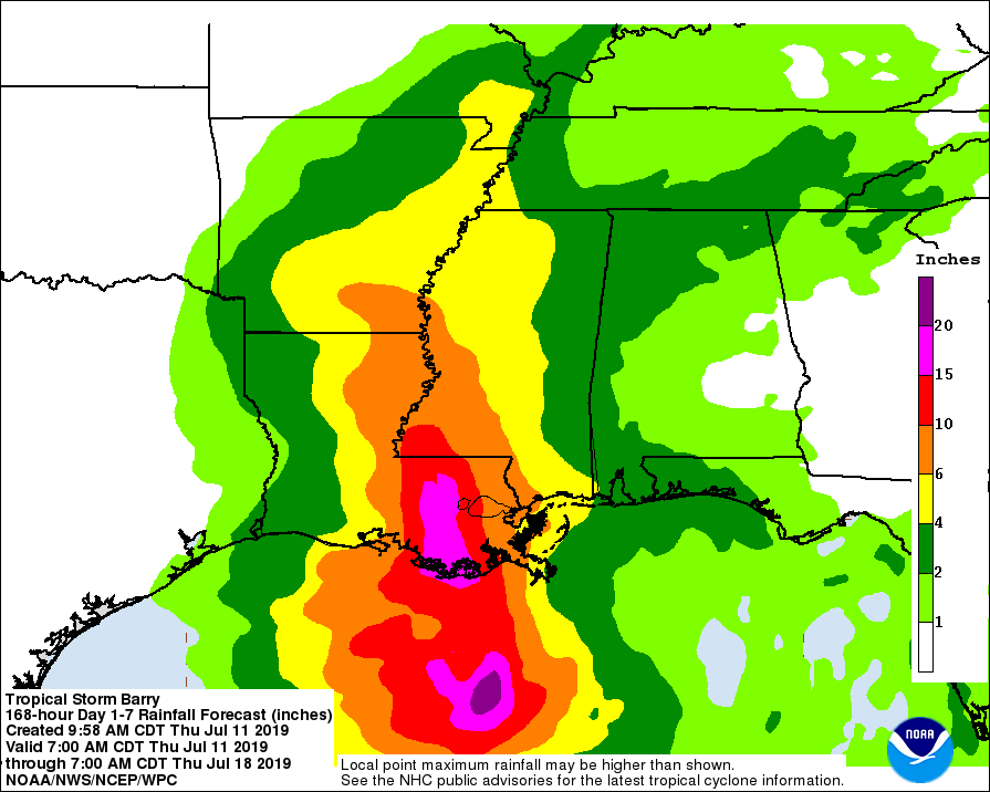
 Update: July 10 - As was predicted, a tropical depression had formed and its projected path could influence the weather over southwest Mo. Although, as the second graphic below shows, heavy rainfall was not projected for SW MO.


Update: July 11 - Forecast of the effects of tropical storm Barry now appear to show it missing most of southwest and south central Missouri.

Subscribe to:
Posts (Atom)