
No matter how you slice up the day, Saturday the 13th of February, is going to pose a problem for many all over the central part of the the US.
Let me begin with the National Weather Services forecast:
‘By Thursday Feb 11, a reinforcing shot of cold air is expected to slowly filter into the region. This will keep daily highs in the lower to middle 20’s through the upcoming weekend. Cannot rule out highs in the upper teens across central Missouri. Overnight lows through the upcoming weekend will fall into the single digits to lower teens. Add in a light wind and wind chill values will make it feel closer to zero or below. This prolonged period of much below normal temperatures could potentially hang on through the middle of February. However, it is worth noting that some model guidance has backed off a bit on how far south the very cold air mass digs in. This will be assessed in future forecasts.’
So, starting with Thursday, it’s going to get really cold outside. And the very frigid core of that arctic invasion will occur on or about Saturday. (Remember to keep an eye on your pets).
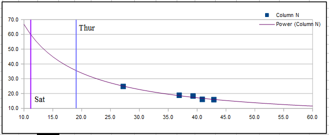
The above scatter chart (that was started on Feb 3) compares actual average temps versus power used. It’s a neat tool that can allow one to predict power demands in the future based on what has happened in the past. (The red line is a power trend line to help with the visualization). Note that on Saturday, with a projected Hi of 21° and a Low of 0° the average temp for the day would be close to 11°. Then it’s easy to see that the purple line representing that average would indicate a power use of 60 kWh’s. That amount of power used would work out costing me ~ 60 kWh * 1.2535/kWh (Liberty Utility rate) = ~$8 for just that one day!
The hope is that this bolus of cold air will not penetrate as far southward as predicted. www.taneyweather.com
No comments:
Post a Comment