Showing posts with label Shadowrock Park. Show all posts

Friday, May 10, 2019

Park flood watch 2019 and a possible solution!

Old pic (2017) of past flood of Bulls Shoals by Shadowrock Park
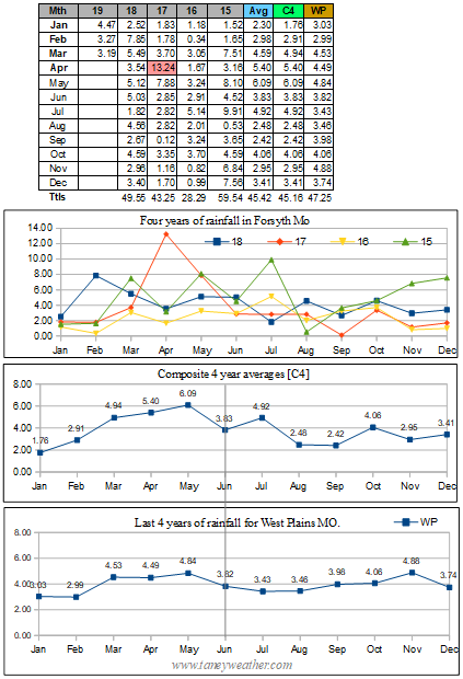
Forsyth MO. - Once again I was destined to sadly watch two area parks flood out. In general this had been happening about every two years or so. And, if you look at the rainfall data I had compiled at right, you can see that even on semi-normal year of rainfall, the parks could still become inundated. So what gives?

Bull Shoals Dam
Part of the problem lies within the state of Arkansas. Whenever that region gets above average rates of rainfall, we here in southwest Missouri will suffer as the Corps of Engineers are often forced to restrict the Bull Shoals dam (located in NE Arkansas) release rates.This creates a situation similar to what the kids did by building a cofferdam in the barrens in the Stephen King novel 'It'. Their actions caused all the sewage in the town of Derry Maine to back up and what a mess that was! That sort of describes what occurs whenever that dam in Arkansas cannot release enough water. The entire Bull Shoals reservoir backs up and large scale flooding results.

Canal in California
What exacerbates the problem, even more so, is the upstream reservoirs of Beaver and Table-Rock lakes which, when above full pools, feed the excess water into the 13 mile stretch of Taneycomo lake when then overflows the Powersite Dam on into Bull Shoals which then floods out valuable real estate. In my limited view, this entire string of reservoirs and dams was poorly thought out starting back in the 50's when the dams were constructed.Yet, perhaps, that was all that could be done at the time...

So what might be one possible solution? My thought was to obtain Federal funding for the construction of a canal, similar to what is commonly seen in California, that could run straight down to the Gulf of Mexico! Such an effort would cost billions of dollars, but could also act as a 450 mile long reservoir that could have mini hydro electric generators installed along it route to supply electricity to the towns and cities that were impacted by its construction. This could be a win-win situation for that entire region of the Central United States.

Friday, April 26, 2019

Will River Run flood out - Part II?

May 2017 Powersite Dam
I paraphrased a National Weather Service forecast of potential doom that was published on April the 26, 2019 to read as follows:

A weather pattern change continues into early next week, setting the stage for a potentially very active week. Medium range computer models continue to advertise increasing low level moisture, southwest flow aloft and a meandering surface boundary near the Taney County area. This will likely result in periods of heavy rain along with the potential for several bouts of severe weather. However, details are still sketchy this far out, and certainly later forecasts need to be monitored as we head through the weekend.

With all three Tri-Lake reservoirs currently at, or above full pool levels, any episodes of heavy rainfall could result in the rapid flooding of parts of Lake Taneycomo (on a temporary basis) and all of Bull Shoals in the long term. Just how the scenario of storms will play out, the exact amounts and locations will greatly affect how severe flooding problems could become. 

It was my belief that the weather should begin to get interesting on or about Wednesday, May 1st. At right is a graphic showing water levels for all three reservoirs. I was guessing that part of the problem was with a restricted rate of flow at the Bull Shoals dam on the Arkansas border. This likely due to the Mississippi River setting record levels! And, since that problem isn't going to go away very soon, I felt that the survival of my two favorite parks; Shadowrock and River Run, would be entirely dependent on how much rain actually fell in the first week of May.

701.48 04-26-2019   12:45 CDT
So, only time will tell... At right Powersite Dam was releasing water on April 26, 2019.

Update: April 27 - The baroclinic zone then meanders near the area from Monday though Thursday as upper flow becomes more southwesterly. As has been previously mentioned, this set up is conducive to periodic showers and thunderstorms with heavy rain potential along with the potential for some strong to severe storms. The most impactful period looks to be Monday night through Tuesday night as a shortwave lifts out of the desert southwest and traverses the area. A corridor of precipitable water values of 1.50" to 1.75" feeding into the boundary with likely result in heavy rainfall.

At right is an animation of flood and high flow conditions for national rivers and streams. Note the condition of the mid parts of the Mississippi river system. That heavy load of flood waters will be making its way down to rivers that help drain the Tri-Lakes as we progress into early May. In my opinion, this could spell trouble for parts of southwest Missouri.

Update: Right on schedule, a massive system arrived on the last day of April to unload 2 to 3 inches of rain all across the region with more to come as we entered bravely into May. That will pretty much seal the fate of the two parks to a watery grave for 2019. Pics to come!

Tuesday, March 5, 2019

Bull Shoals levels holding in there!

Forsyth Mo. - Thanks to a somewhat lackluster start to March 2019 in the rainfall department, the Bull Shoals Lake levels had dropped back down, just a bit, with the trend likely to continue until around March 8 and 9 when storms were forecast to impact the region. That said Beaver Lake was 1.63 feet above full pool and thus posed a potential problem if we were to be inundated with heavy rains at any point in the month! Please note that the level at which the Corps of Engineers would actually close River Run is mere conjecture on my part.


Update: March 5 - Powersite dam was running strong!And, the Corps must have also been releasing at the dam by the border as River Run Park looked to be in fairly good shape with the water level at 667.47 feet.

Update : March 6 - The lake levels continued to drop, so that was good news. The only fly in the ointment was the unsettled weather pattern that was shaping up towards the start of the second week of March! This from the NWS: "Amplified upper-level flow returns for Tuesday and Wednesday as the models hint at another robust shortwave trough digging across the Dessert Southwest, with its axis taking on a negative tilt as it aims toward the central and southern Plains, as well as the Missouri Ozarks."

Update: March 8 - Bull Shoals water levels now below flood stage for River Run. And, it looked like no real heavy rains were in the immediate future!This from the NWS: At this time instability appears to be more limited across the area with the better thunderstorm potential looking to remain southwest of the area at this time.

Update: March 9 - I recorded a .81 inch rainfall that looked like it covered pretty much the entire Tri-Lake region. That much rain could pose a problem for rising lake levels.

Update: March 10 - After the region got a good dose of rainfall, Bull Shoals was still trending slightly downwards. Good news! However, as the current NWS forecast for the coming mid work week was: ' A cold front will sweep across the area Wednesday into Wednesday night. Lift will increase across the area resulting in widespread showers to develop across the area Wednesday and Wednesday evening. Three quarters to one and one quarter inches of rainfall is expected with this system. A few embedded thunderstorms will also be possible, but overall instability appears to be more lacking and not expecting any severe storms at this time. Northwest flow then sets up across the region late in the week and will result in below normal temperatures into next weekend.' So, another .75 to 1.25 inches of rainfall would keep things interesting. Stay tuned.
www.taneyweather.com


Monday, February 18, 2019

Will Forsyth MO area Parks flood in 2019?

Forsyth MO. - I was very much looking forward to a few new features in my small town of Forsyth Missouri in southwest Missouri this coming spring. A new bridge over Bull Shoals, a new roundabout and two parks that all looked to be in great shape!

But wait! There might be a fly in the ointment and that was the potential for both River Run and Shadowrock Parks to be flooded out early in the coming 2019 season! How could this happen, you ask?
Click to expand
Well, my fears grew somewhat when I realized that the water levels in Bull Shoals as well as the other two reservoirs (Beaver and Table Rock Lakes) upstream of it were much higher than they normally were (see graphic above). And with the spring season not even here, I noted that River Run was already becoming invaded on its northwestern shore! I just could not see how the Corps of engineers were going to manage their way out of flooding problems even if we have a typical amount of rain in March and April. (Perhaps they were hoping for a mini drought to occur....).

Graphic 2
As I considered the situation, and the fact that our rainfall had not been all that excessive over past six months (graphic 2), I turned my focus on the Bull Shoals dam down by the Arkansas border. I had to guess that they were simply unable to release as much water as they normally would possibly due to the time of year, when water absorbing foliage was not present. (Either that was the case or there were other issues occurring somewhere between that point and the gulf that I was unaware of...).

Whatever, the answer to the flooding question was going to resolve itself over the next couple of months, of that I was certain, I was just hoping for a chance to get in some 'Park' time early in the spring before anything of a wet nature happened.

Update: Feb 20, 2019 - River Run Park. The flooding of part of this park had begun!

Update: Feb 24 - With just a few days to go in the month, it was looking as though the River Run Park area would be flooded out! And, it wasn't even the start of the spring season! We'd really need a serious dry spell for, say, the first few weeks of March to get the levels back down.