Saturday, October 26, 2019

Snow in October

Forsyth MO. - It was late October, but I sort of felt that was a tad early for the National Weather Service to be talking about the chances for snow;

Staggering differences in model solutions remain during the
Tuesday through Friday time frame, but all global models indicate a
strong surge of cold air between Wednesday and Thursday. Thus,
that will be the message of the forecast; and not the potential
for measurable snow. The GFS remains the most progressive with
the upper-level shortwave and the surge of cold air, as a
TROWAL/deformation axis develops over central Missouri
Wednesday/Thursday with banded measurable snow. On the other hand,
the CMC and ECMWF offer much slower solutions with the upper-
level pattern, suggesting a warm and rainy Wednesday/Thursday.
These latter models then bring the cold air in Thursday/Friday
with a prevalent dry slot, thus, limiting snow chances.

For now, we have gone with our model blend for temperatures and
precip type from Tuesday to Friday. Temperatures Tuesday and
Wednesday will exhibit highs in the 40s and lows in the 30's.
Then, Thursday and Friday will feature highs in the 40's and lows
in the 20s. Right now, we aren't mentioning more than a 0.5" of
snow across our area for next week.
 
Whatever does happen, it looks like many of us, living in Taney County Missouri, will be getting a does of some winter like temperatures. A trend that looks to continue right on into early November....

Here's the forecast map for Monday,  Oct 28 - That don't look very good to me...


Monday, October 14, 2019

Going into the fall and winter of 2019-20!

Forsyth MO. - After the rather wet and hot summer of 2019, all eyes turned to expectations of what kind of winter we might have and then going forward into the sprint of 2020, whether or the not the area parks would flood once again!

At right is a pic of the last five years of rain I've recorded for the Forsyth Missouri area. The C4 column is an average of the last four years not counting this year. One interesting note was the fact that those four years were statistically behind the 30 year posted averages for West Plains, MO. This year was looking to come in about normal, although it remained to be seen if that would come true.

As far as the Winter months for 2019-20 were forecast, the thinking was for a possibly colder and dryer than normal December through February period for the state of Missouri. See https://youtu.be/VGZJ8tSFLDs for a full video forecast. All indications, then, were that both Shadowrock and River Run parks would remain high and dry.... OK. I can live with that!

Wednesday, September 18, 2019

What hotter than normal nighly temps mean!

In 2015, the National Oceanic and Atmospheric Administration noted that, "As the world warms, nighttime temperatures are slightly outpacing daytime temperatures in the rate of warming."

The following year, 2016 ranked as the third warmest year ever in the United States when looking at average temperatures. But when looking at the nation's overnight minimums, 2016's were the warmest ever. This summer beat that record again, with the nationally averaged minimum hitting 60.9 degrees Fahrenheit in the contiguous U.S.— 2.5 degrees Fahrenheit above average.


My data for 2019 (for the first half of the month of September), which should see average nightly lows at about 58 degrees have been blown out of the water... The above graph shows that, on average, we were 14 degrees warmer than what had been the average for the past thirty years....

Monday, August 12, 2019

High temps may cause electrical outages!

Forsyth MO - After having a conversation with the Liberty Utility folks who provide power to my area, I came to the conclusion that during periods of higher than normal use, some areas can expect power outages to become more the norm rather than the exception.

After experiencing an outage on Friday, July 19 that lasted for a number of hours, I received this email test after complaining to Liberty Utilities (see post entitled July 19 power Outage:

'Unfortunately we cannot promise service 24/7 but when we do experience an outage we respond as quickly and safely as possible. We did have and issue with a substation,  we can’t predict when this might happen however with the extremely high heat index we have experienced that may cause extra load on our equipment. With our lineman responding quickly and our customers conserving usage we will do our best to make sure outages are as infrequent as possible.'

The admission that high heat indices, like the 110 degree one expected on this date (August 12, 2019), lead me to issue my very first prediction....

'Look for numerous and widespread power outages all across southwest Missouri to occur as outdated and insufficient power grid resources are anticipated to fail under the increased load caused by so many AC units running like mad.'

That is my prediction in the early morning hours of the day. I'll sit back as now watch to see what occurs....

Monday, July 22, 2019

The road to a dam fix!

Only one small gate section remained up (far left)
Forsyth MO. - On June the 28th, 2019, the Powersite dam suffered a problem when a piece of debris managed to sever a pneumatic line that held the top portion of a moveable gate in the up position. After the failure, water levels on Taneycomo Lake to drop several feet from about 702' to 699' above mean sea level. This caused many docks to end up resting on the mud bottom all along the thirteen mile length of the lake. After that it was a waiting game as repairs could not be effected until the water level on the Bull Shoals side of the dam dropped to at least 685 feet!

So, a reasonable question might be, 'How long will we have to wait?'

Well, assuming a typical dry summer stretch that is often seen in July and August, the answer becomes one of simply looking at trend lines. That is, extending the average rate of the drop of water levels over a period of time in order to extrapolate how far in the future you have to go to get to that magic number 685! Here's the current graphic;

Note that if you click on the above graphic, you can see that the water level should have fallen to 685 feet by about August the 12th! That's assuming no heavy rains and a relatively constant rate of release at the Bull Shoals dam. A nice long dry spell all across the region could speed things up a bit, especially if the Mississippi also goes down to more normal levels!

Update: July 27 - Newly established water level trends would seem to indicate that Bull Shoals could drop to acceptable levels for a dam repair by early August.

  Update: July 29 - Gates had been repaired and water levels on Taneycomo were coming back up!


This media release from Liberty Utilities: 'Crews were able to safely access flood damages at our Ozark Beach dam yesterday, July 29, at 11 a.m. Crews were able to replace a damaged airline, which when repaired, allowed all three sections of flood gates to be raised. Taneycomo water levels reached their normal level of 699.75 ft. by 2 p.m. Until the Bull Shoals lake levels drop, water will continue to go over the dam rather than through our generators. Liberty Utilities personnel are evaluating the incident and options for preventing similar flood damage in the future.

Plant Manager, Randy Richardson, says, “I’d like to thank everyone for their patience, and I’d like to thank our crews for their quick work once lake levels allowed for safe repairs. Improvements made to the dam in 2008 allowed us to make repairs more quickly than in past floods, and we will continue to look for ways to strengthen our equipment and improve service and reliability for our customers.”' J. Curtis Communications Media Coordinator-Assoc

Tuesday, July 9, 2019

Tropical depression likely to form in the Gulf!

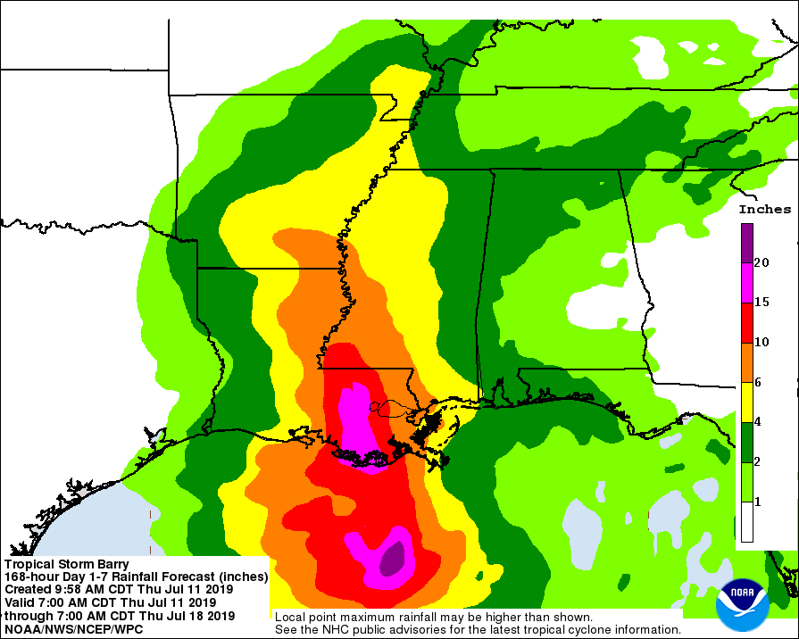
NHC: There is a high probability (80%) that a tropical depression is likely to form by the end of the week over the northern Gulf of Mexico. This system also has the potential to produce heavy rainfall along portions of the northern and eastern U.S. Gulf Coast later this week.

--------------------------------------
My thoughts: An early and active hurricane season could perhaps spell trouble for the Tri-Lakes group of reservoirs in southwestern Missouri should such a tropical depression ever happen to impact the Gulf of Mexico region, in my opinion. Such systems can sometimes (rarely?) act as a moisture pump that can bring heavier than normal rains to the Central North American states!

Table Rock Lake was currently at 921 feet with a flood pool set at 931'. If water levels were to get that high, the Corps of Engineers would be forced to open the ten Tainter gates two and a half feet allowing 150,000 cubic feet per second of water to be released into Taneycomo which would not be able to hold back any water due to a damaged air bladder mechanism. Such an event could pose problems further downstream. [Note: Repeated attempts to contact the Corps had failed to elicit any useful information concerning repair time estimates.]

Update: July 10 - As was predicted, a tropical depression had formed and its projected path could influence the weather over southwest Mo. Although, as the second graphic below shows, heavy rainfall was not projected for SW MO.

Update: July 11 - Forecast of the effects of tropical storm Barry now appear to show it missing most of southwest and south central Missouri.

Monday, June 17, 2019

What the heck was going on with the month of June 2019?

Forsyth MO. - As a layman weather observer of over twenty years, I've watched the seasons come and go in my small town down in southwest Missouri. In general, we get pretty docile and boring weather pretty much year round. Sure, there may be that surprise snowfall in February or a semi-heat wave in July or August, but for the most part the weather is pretty boring. At least, that was the case up until this spring when something changed...

Even as early as late February, I was posting warning of potential problems with rainfall and the effects that would be seen on area parks! Back then water levels were on the rise as record rainfall fell in parts of Arkansas. Up to the north, a series of snowfalls across the Central northern states also became something to watch. There was certainly a boatload of water stored in the form of snow late in the winter season. Then as March 20 came and went and we got into the start of the spring season, all that water began to melt. And, over on the Mississippi, the water began to rise.

Things went downhill from that point, such that by late April there was talk of heavy rains impacting an already soggy southern Missouri and northern Arkansas! And the rains did come and they hit all over the central tier of states! Crops were lost, rivers became engorged and it was still relatively early in the spring season. Still, in my neck of the woods, it had been a relatively normal period of time (See graphic below).
Click on to expand
Rainfall was pretty normal and yet the water levels in the three large reservoirs (Beaver, Table Rock and Bull Shoals continue to rise). Then in mid May, things got rather nasty as tornado outbreaks became common for a short period of time!

Interestingly, my small town of Forsyth escaped 'most' of the storm action, even as its two parks (Shadowrock and River Run) began to submerge into the debts!

That brings us to mid June and yet another anomaly. If you look at the graphic showing the month's high and lows, it was very apparent that we were having quite the cool spell.

Click to expand

Wow! Four degrees below the thirty year average was pretty exception and it made me wonder what else 2019 would bring...