Saturday, January 27, 2018

Taney County weather going into Feb 2018!

SUNDAY – MONDAY [JANUARY 28]

On Sunday, a shortwave trough drops through the flow with an increase in 850mb-700mb moisture during the day and then moves across the area Sunday night with its associated cold front, so expect another mild day with highs well into the 50's. As the front/wave moves through Sunday night, models are beginning to indicate the potential for some light precipitation across the northern counties. At this point, thermal profiles from both the NAM and GFS would suggest light snow and or flurries. We are not expecting anything impactful (sp?), but could see a very light dusting at most. This will quickly exit early Monday morning with high pressure then building down across Kansas and Oklahoma for quiet but colder conditions both Monday and Monday night, as highs drop back into the 30's to near 40 and lows in the teens and 20's.

TUESDAY

The surface high moves off to the east Tuesday, with winds coming around to the south. The pressure gradient really tightens between the departing high and a strengthening cold front over the Plains. The combination of rising mid level heights and strong south to southwest winds will result in a warming trend, bring afternoon highs back into the 50's by Wednesday. In addition, these stronger winds Tuesday afternoon will result in elevated fire weather conditions, which may persist into Wednesday as well.

WEDNESDAY

It is still looking like there will be a potential for some winter weather Wednesday night and Thursday. However, confidence remains rather low in terms of precipitation type and amounts. A cold front is poised to move through Wednesday night ushering in colder air. The question will be the timing of precipitation onset. GFS is a little more bullish on QPF amounts versus the ECMWF, from Wednesday night into Thursday. It is still much to early for any specifics and as such will continue to mention a rain/snow potential. It is something to certainly keep an eye on since there could be potential impacts.

THURSDAY on...

Both the GFS and ECMWF pushes system through Thursday night with Friday and Friday night looking dry but cold. Catch more of my junk at www.taneyweather.com!

Friday, January 26, 2018

Are we in the midst of global warming? Yes, we are!

Taney County MO - In referencing the graphic above concerning the average temperatures, this year versus 2017, it was nice to see that the trend was headed upwards in a fairly normal fashion! Other than that rather nasty bout of frigid weather in the mid portion of the month, we've been following the 'global warming' forecast trend rather nicely. In January alone, we've enjoyed temps that have been 7 degrees Fahrenheit above the normal high and 13 above the normal lows! (And, as many people know, it's those elevated night time lows that are the most telling when it comes to talking about climate change). Not that I feel there's anything wrong with it being warmer than it used to. While many environmentalists wring their hands over rising global temperatures, I'm actually very happy. The truth be told, when you have a planet whose population is rising now towards 8 billion, you gotta expect a few unpleasant surprises. Remembering that even though the United States does throw out a lot of carbon dioxide, those amounts for America versus the shear magnitude of the other seven billion plus people in the rest of the world are relatively tiny. Billions of very poor people must cook and heat their 'homes' with an open fire. The carbon dioxide emitted by the practice is absolutely humongous. And sadly, the only way one could change that equation would be to kill off at least half the population! That ain't gonna happen (I hope), and so the global temps will continue to rise. (Thankfully, by the time any really serious effect are felt, quite a large amount of time will have passed). Scientific American published a great article on the topic in which they stated;

In less than 1,000 years, if consumption continues to increase at the current rate, we will have exhausted the currently known reserves of coal and oil. By that time we will have multiplied the carbon dioxide tonnage of the air 18 times. When the ocean–atmosphere system comes back to equilibrium, the concentration of carbon dioxide in the air will be 10 times greater than it is today, and the earth will be 22 degrees warmer. In another few thousand years, when the carbonate content of the oceans has reached equilibrium, the concentration will still be four times greater than it is today. The earth's temperature will then fall to about 12.5 degrees above its present average.'

So, things look to warm up quite a bit, but will not be terribly punishing to humanity for a number of centuries. [Note: Most of the doom and gloom predictions assume that nothing changes and that we will all continue to throw CO2 into the air with wild abandon. Yet in all likelihood, humanity will have managed to kill off itself much sooner than that]! There exists an elephant standing right in the middle of our room that everyone is ignoring. Please see my post on the coming Water Wars for what is even more likely to happen in just a few decades!

Sunday, January 21, 2018

Week 3 in January 2018!

MONDAY – JAN 22

Winds will remain gusty through the day Monday as the upper low makes its way across northern Missouri through the day. Light rain or showers will be possible as the wrap around moisture slides along with the low. As temperatures fall, some snow may mix with the rain across portions of central Missouri Monday night. No snow accumulations are anticipated.


TUESDAY

Strong surfacelow pressure over the Great Lakes will move off to the east as a ridge of high pressure over the Plains edges east. Expect northwest winds to gradually continue to diminish during this period. A shortwave will move southeast into the area by 12z/6am Wed but there is only a slight sfc reflection of this in pressure fields and only minimal cloud cover this far south.

WEDNESDAY

Looks quiet with a north-south oriented surface ridge axis moving through the region. I plan to take a long nap!

THURSDAY

South-southwest winds will increase as the sfc high shifts east and low pressure moves into the High Plains. Daytime highs in the upper 50s to around 60, afternoon humidity near 30 percent, and winds gusting to 30-35 mph over the western Missouri Ozarks Highlands into west central MO and southeast KS will heighten the fire danger. Our western cwfa missed out on significant precip with the last storm. In any case, one hour lag time grass/brush fuels will dry out quickly.

FRIDAY & SATURDAY

There is good agreement with guidance (other than some minor timing differences) for this period with a sfc low tracking well to the north and a trailing sfc front approaching and moving through Fri night-Sat. Looks like we will see a good chance for rain/light showers. Rainfall amounts don't look too
impressive with a lack overall moisture in a prefrontal highly modified Gulf air mass.

www.taneyweather.com

Sunday, January 14, 2018

A nice Jan 14 snowfall!

Forsyth MO. - Beginning sometime early on January the 14th, in southwest Missouri, a lot of folks got a real introduction to the winter of 2017-18 with the first decent snowfall in many a moon.

At my station, located in Forsyth Missouri, I was pleased to see this event happen as snow acts as a good insulator for plants and wildlife. (Please see my short video that shows the early onset)! This could prove to be especially important when one considers the brutal temperatures that will be arriving sometime on Tuesday! Also, thankfully, the main street appeared to be in good shape with plows out and about on the side streets. So, a nice looking and non-threatening gift from God that most of us can enjoy!

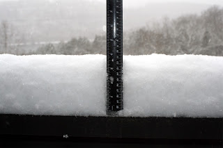
By the morning of the 15th, the snow had reached about 4 inches as of 10:00 AM with a light snow still falling!

Jan 14 snow day!


So, we have us some freezing temps, snow and slick roads. Hey! What's not to like! A January 14, 2018 short look at someplace near Forsyth MO. Just the kind of day to hang out in bed, with a cup of warm coco watching TV!

But, stay tuned for even more winter zaniness as temperatures are forecast to really bottom out on Tuesday, January the 16th!

 www.taneyweather.com

Friday, January 12, 2018

Weather for Jan 14 thru the 19th in Taney County!

SUNDAY, JANUARY 14

So, you think that perhaps maybe we're all due for a bit of a respite as the weekend winds down? Forget about it! A slightly stronger clipper like system will dive through the deep northerly flow Sunday morning across our region just in time for you to walk the dog. Models indicate enough moisture may be squeezed out for a quick band of snow flurries or light snow Sunday morning into the midday hours. The best potential of a light dusting to up to half an inch of snow will be north of Highway 60 which be the northern half of Springfield and which would not affect Taney County.

MONDAY

On the heels of the upper disturbance which brought 1-2 inches of snow from last night into Sunday, the next one will begin to arrive tonight, with snow expected to start up in central Missouri close to midnight and then spread southward across the remainder of the area overnight into Monday morning. Snow should end during the early afternoon across far southern Missouri. Another 1-2 inches of snow is expected with this disturbance, however temperatures will be falling throughout the day after a cold front moves through during the morning. Temperatures will likely dip into the teens to low 20's by the end of the afternoon with wind chills in the single digits. It will also be windier with the snowfall than it was with today's event, so there will be more blowing of snow. We will be issuing an winter weather advisory starting tonight at midnight and going through noon Monday for the snow.

TUESDAY

If there is fresh snow on the ground...we will see bitterly cold temperatures Monday night through Tuesday night with lows near or below zero and highs on Tuesday only in the lower to middle teens.

Potential wind chill values could drop as low as 10 to 20 below zero which is dangerously cold. I think even Nome Alaska might be marginally warmer...


ONWARD

The overall weather pattern flattens out and southerly winds return late next week with milder temperatures. This is a little too far out to have a very good handle on... but, here's a spoiler - anothe even more vicious Arctic Vortex may be in the offing!

 www.taneyweather.com

Sunday, January 7, 2018

January forecast for work week 8-12!

MONDAY - TUESDAY

For those of us who have been watching their electric meters spin, an overall milder weather pattern will develop beginning Monday. Thank goodness as we could all use a break! Look for 40ish weather, day time and near freezing overnight.

Very rapidly we are getting towards the mid part of January when the fun stuff - blizzards, snowfall and ice storms are slightly more likely to occur...


WEDNESDAY

A more zonal pattern and a return of warmer southerly winds will result in a warming trend with highs back in the 50's by Wednesday. I can live with that!

For Wed late, main upper level shortwave will track into the plains with precipitation beginning mainly after midnight in the form of rain. Temperatures will remain mild overnight in the low to mid 50s most places, with the front approaching the northwestern CWA by 12z. 

THURSDAY

We have gone with non-traditional diurnal temperature curve for the temperature forecast on Thursday with sharply falling temperatures behind the front. Those 50 degree readings at 6 AM will fall into the mid 20s to mid 30s for much of the CWA by 6 pm. So even though it may be a non-coat start to the day, you will definitely want it for the drive home.

With the temperatures sharply falling below freezing behind the front during the day, precipitation will transition to a brief (1-3 hr) period of freezing rain and sleet before changing over to light snow before the precipitation ends. We are only anticipating a couple to few hundredths of ice accumulation with this system and maybe a trace up to a half inch of snow. What could go wrong with that scenario?

The precipitation should end by 12z Fri.