Sunday, December 31, 2017

Taney County work week 1 in 2018!

MONDAY – January 1

Welcome to a New Year and Ice Station Zebra! The center of the surface high that has been responsible for the arctic chill down will move deeper into the area Monday and Monday night. Therefore similar conditions are expected to what you all have become used to the last couple of days. Winds will thankfully become lighter, but with temps below zero it only takes a 3-5mph wind to send wind chills back to -10 or below.


TUESDAY – January 2

The Wind Chill Advisory runs through midday Tuesday. Several records for low temps are in jeopardy on this date. Other than that, it will be a pleasure for many who will be returning to work. Assuming it's an indoor job, that is!


WEDNESDAY - THURSDAY

Surface high moves south of the area Wednesday and winds will switch around to the southwest. (About time)! Temps will start to rebound for a short time, however another shot of cold air comes down Wednesday night into Thursday. This insult will be more of a glancing blow, mainly affecting the eastern half of the area with the coldest temps. Here in Taney County it will only be in the teens...


FRIDAY – January 5

By Friday, the southwest half of the forecast area should see temperatures climb above freezing for highs with areas in central Missouri in the mid to upper 20's. However, the upper pattern will be in transition as the upper trough shifts eastward and ridging begins to move into the plains. Our temperatures by Saturday should reach the mid 30's northeast to mid 40's southwest.

SATURDAY

Precipitation should begin to move into the area Saturday night and continue through the remainder of the weekend as an upper level system shifts east through the area. Most of the time period looks like it would be in the form of rain, with some chances of snow thrown in with the colder nighttime temperatures.

SUNDAY

Models show light precipitation developing over southeast Kansas into southwestern Missouri by sunrise Sunday. One aspect is for certain, the ground is cold and frozen with several inches of frost depth. The question then remains how the air temperatures will respond and how quickly does the area warm up above freezing Sunday morning into the afternoon as warm air advection moves in. The freezing line will slowly retread from west 
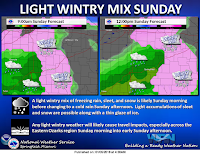
to east during the day Sunday. A light wintry mix of freezing rain, sleet, and light snow will progress across the area especially along and east
of Highway 65 Sunday morning. As temperatures warm up above freezing, it will turn over to a cold rain. A light glaze of ice along with a coating of light sleet and light snow look increasing likely for areas along and east of Highway 65. The greatest potential for minor accumulations will be over the eastern Ozarks where temperatures stay coldest the longest. Some travel impacts look likely over the eastern areas.

Most of the area changes over to cold rain late Sunday afternoon. As temperatures drop back down Sunday night, some of the rain could change back over to a light wintry mix again before ending from west to east. Overall a general half an inch to three quarters of an inch of rainfall may be possible with this system.

A milder and drier weather pattern returns for early next week with above average temperatures. High temperatures in the 50s will return by the middle of next week. There will be another storm system to affect the area by Thursday with rainfall. Colder air will return on the back side of that system and change the rain to snow later in the week.


Thursday, December 28, 2017

New Year's weather forecast for Taney County!

A tricky forecast for Friday and Friday night with a sneaky drizzle event possible before the arctic front comes through late in the night or early morning Saturday.

Friday, December 29

Southerly winds were keeping temps in the teens and low 20's for the most part across the area this morning. While some low clouds were exiting east, other mid to high clouds were moving in. Do think that clouds will move back in for most of today. Another contrast in temps from north to south will occur today as thickness values increase across southern Missouri. A little hesitant to go as warm as guidance, even with southerly winds. Locations along and south of Interstate 44 will approach 40 with locations across Central Missouri only making it into the low 30's. Feel free to get out there and enjoy the warmth!

Forecast soundings for this afternoon for Central Missouri (Warsaw over to Vichy), shows a general lack of cloud ice with relative humidity readings of around 40-50% along with a moist layer below 850mb along with some lift in that layer. With temps around freezing, we do think that some freezing drizzle may be possible with better chances just northeast of the area toward Jeff City. 00Z/06Z NAM, along with latest hi res models do show this signal. Not confident enough yet to issue a advisory for this area however model trends along with surface temps/high's will need to be monitored today. With a cold ground, even just a little freezing drizzle can cause some impacts.

Hi resolution computer models and the NAM then show an area of drizzle potential across the rest of the Missouri Ozarks after midnight tonight, just ahead of the Arctic front. Model soundings vary a little on how much cloud ice is present, however a warm layer exists around 850mb with lift in that layer. Again, surface temps will be critical in determining the impact here, especially with southerly winds. Definitely need to monitor the drizzle potential tonight as ground temps are cold. The Arctic front looks to arrive across our far NW counties by 12 midnight and then clear through the area by 6AM. This event then begins a period of much colder temps.

SATURDAY – December 30

Cold air advection will be in earnest Saturday and Sunday as a 1050mb+ surface high sends some very cold air south into the area. Temps will likely fall all day Saturday with temps in the teens and single digits by evening. We can't rule out some flurries across far southwest Missouri Sat night, but most will likely stay just south of the Taney County area.

The 850mb (5000 feet up) temps drop close to -18C (-.4ºF) during the late Saturday through and Monday time frame. This looks to be a very cold stretch with highs in the teens and lows in the -5 to 5F range. Gusty north winds will continue as the pressure gradient doesn't really let up until closer to Tuesday. Winds look to remain near 10-15mph during the weekend. Therefore wind chill values Saturday night into Sunday morning will drop to -10F.

SUNDAY - MONDAY

Sunday night into Monday appears to be the most dangerous as wind chill values drop to as low as -25ºF. Wind Chill Advisory criteria is -10ºF and Wind Chill Warning criteria is -25ºF. Confidence is high that Advisory criteria will be reached and look for those to be posted possibly later today. With New Years Eve being Sunday, there will be additional impacts as more people may be out and about and/or traveling.


TUESDAY - We get hit again!

The center of the high moves over the area Tuesday however another shot of cold air moves down Wednesday and lasts through Thursday. Ain't we the lucky ones!

Monday, December 25, 2017

Christmas work week forecast!

MONDAY – DECEMBER 25

A cloudy yet quiet day with the high temperature only in the mid 30's. Monday will likely be the warmest day of the work week! Hoping everyone has a safe and a Merry Christmas!


TUESDAY - WEDNESDAY

Chilly northeast breezes continues tomorrow as highs only make it into the upper 20s and lower 30s. A couple flurries are not out of the question, but certainly no accumulations.

THURSDAY

Another upper level wave will pass overhead on Thursday. Models are not showing much QPF with this system either, although we could see more flurries with Thursday's wave.

FRIDAY

Friday will be the "warm" day of the week before another surge of cold air begins to move in Friday night. Bitter cold will be the main highlights of the forecast for the weekend and New Years Day before temperatures moderate somewhat by midweek. Some very light snow or flurries will be possible at times this weekend. Temperatures will moderate a little with some s-se winds. Some highs in the low 40's may be possible in our southern MO counties with 30's elsewhere. So, some of you might want to go shinny dipping in your local pond....

FRIDAY NIGHT

A bitter arctic air mass will settle in over the region for this period. As the cold air first comes in, we
could see some frontogenetically induced flurries/light snow late Fri night into Sat. Nothing major. However, given the high snow:liquid ratios it won't take much to get a light accumulation.
Guidance is also showing some upglide into southern MO into cold air dome late Sat night into Sunday morning. Again, a light fluffy accumulation (< 1 inch) is in the grids for parts of southern MO. There is fairly low confidence in this right now. We certainly aren't looking at a big snow dumper during this forecast period, but any flurries and light accumulating snow will just add insult to injury given how cold it will be.

Forecast guidance which had been quite variable as far as temperatures are concerned are now finding some middle ground. The coldest period looks to be Sunday through Monday night. Some below zero temperatures are expected for early New Year's morning.

LOOKING AHEAD

Some weak moderation in temperature is expected Tuesday as the center of the cold sfc high moves off to the south and another trough approaches from the northwest. By Wednesday, guidance diverges in the timing/position of another Canadian high moving south into the area. In general it does look like we may see some moderation in temperatures later in the week (beyond Wed) as the upper flow tries to become more west-east zonal over the central CONUS. www.taneyweather.com

Friday, December 15, 2017

Taney weather for work week Dec 18-22!

MONDAY - FRIDAY

Yawn! Temperatures heading into Monday and then on through the week will remain in the 50's during the day with overnight temperatures in the 30's for the most part, thanks to continuing southwesterly flow aloft across the region. For me that translates into a cross between hibernating and hitting the bars!


THURSDAY

Very warm and breezy conditions are expected on Thursday as a surface low and cold front move into KS/OK area. There are still timing differences among various guidance sims concerning the fropa (frontal passage) timing and this is mainly dependent on how strong surface waves will develop along the front. The warm sector is initially characterized by modest low level moisture and not much in the way of rain chances. This gradually changes as the front moves into eastern MO.

FRIDAY


The main focus for Friday continues to be the potential for snow from Friday night into Saturday morning. Models continue to depict a short wave trough pivoting east across the region during this period, with this wave shearing (weakening) with time. An area of rain should initially expand from southwest to northeast from the Arklatex into southeastern Missouri during the day on Friday as low and mid-level frontogenesis strengthens ahead of that approaching short wave trough.

One of the keys to the forecast will then be how much additional precipitation development can take place farther north into the "cold sector" of this developing low pressure system from eastern
Oklahoma into southern Missouri. Close inspection of model cross sections indicates that this window may be shrinking from both a spatial and temporal standpoint.


SATURDAY

Unseasonably cold air will move south out of Canada during this time. Can't rule out some flurries or a light dusting accumulation in some spots, especially Sunday, with the passage of a shortwave, but again, not looking at much if anything at all. Christmas Day may be a struggle to get above freezing in many/most areas.

SUNDAY

Digging energy across the Plains may then bring another chance for some light snow to the region from late Saturday night into Sunday. There are still considerable differences regarding the track of this energy, thus we have kept PoPs in the 20-30% range for now.

Global models from the early to middle portions of next week are then struggling from a consistency standpoint. We went on the cold side with temperatures as GFS five wave charts indicate a good
signal for cross polar flow and an amplified trough over eastern North America. There are some signals for more precipitation chances by midweek, however confidence remains low due to the aforementioned inconsistency with models.


 www.taneyweather.com

Friday, December 1, 2017

December work week numero one for Taney County!

MONDAY - TUESDAY

A big trough will develop and dig across the central U.S. Early this week. A strong cold front will move into the region Monday afternoon. Monday will be a warm and windy day with some wind gusts over 35 mph possible. Model guidance indicate a few shower possible over eastern Kansas by late Monday morning to midday. A broken line of storms will quickly develop right along the cold front by mid to late afternoon Monday. Most unstable CAPE values may be up to 1000 J/KG along with very strong shear. There appears to be at least a marginal threat for a couple strong to isolated severe storms possible across the Ozarks Region Monday afternoon into Monday evening. Given the dynamics, isolated wind gusts up to 60 mph may be the main threat. The great chance of rainfall and amounts will be along the I-44 corridor and southeastward. The front and storms clear through the Ozarks region shortly after midnight.

The upper level trough continues to establish itself over the Midwest and Great Lakes Region by Tuesday. It will be a cool and breezy day across the Ozarks.

WEDNESDAY

A deep trough weather pattern sets up across the Midwest and eastern U.S. for the middle of next week with deep northerly flow across our region. High temperatures will only be in the upper 30's to low 40's with overnight lows in the 20s. It looks like we will likely see a couple shortwaves riding through the upper level flow of the trough and associated fronts which will reinforce the colder weather for the latter part of the week.

THURSDAY - FRIDAY

Guidance continues to show a strong shortwave digging and moving across the Midwest Region into the Ohio River Valley on Friday with a clipper like system moving across the area. This feature may bring another chance for snow flurries across portions of the region. At this time, we do not see any impacts but will monitor future trends. The latest guidance has come in colder for the end of the week and forecast temperatures have reflected that. We will likely see highs only in the 30's and overnight lows in the teens and 20's. Wind chills may drop into the single digits by Friday and Saturday. Some moderation in temperatures may return by next weekend.

No matter what, it will definitely feel more like winter next week. So dig out the winter coats and make sure you're full of eggnog before heading out!

www.taneyweather.com