Tuesday, March 16, 2021

Severe weather watch for Wed, Mar 17!


Hopefully, everyone living in southwest and the central parts of Missouri will have made sure their personal weather alert radios are checked and are on!

Wednesday, March 17, 2021 looks to be a likely day when portions of southern Missouri and northern Arkansas may see some potential develop for super cell development along with attendant chances for large hail and tornadoes.

I plan to be keeping tabs during the day on Wednesday and will be posting updates right here. Note that you can get real time data at my personal weather station (KMOFORSY5) located in Forsyth, Missouri! www.taneyweather.com

Friday, March 5, 2021

Unstalble weather for mid March 2021!

NWS - 'Overall looking at a more active pattern starting in the middle of next week (March 10). While details such as timing, moisture available, and system track are uncertain, the pattern is supportive of potential for thunderstorms, including the potential for strong to severe storms and flash flooding across portions of the central U.S. Again, it is too early to predict associated hazards across our area, so stay tuned to the forecast over the next few days.'

Last year, March 11th saw the start of a period of heavy rainfall that resulted in a month that saw 7.67 inches of rain at my location in Forsyth Mo. Very often, the last part of March can act a signal as to what trends can be expected as we enter into the 'wet months' of April and May.

Sunday, February 21, 2021

Spring 2021 weather outlook!

Despite Old Man Winter's fashionably late arrival, he made a no-holds-barred entrance. And AccuWeather forecasters are warning in the company's annual spring forecast, released this week, that the winter hits may keep on coming even well into spring for some regions.

It could be a long ride of wintry weather as the official start of spring is still about six weeks away. Astronomical spring officially begins at the equinox, which will occur at 5:37 AM EST on March 20, 2021, and nearly three weeks after the start of meteorological spring, which, year in and year out, starts on the first day of March.

Similar to the winter months, the overall weather pattern across North America will be influenced by a phenomenon known as La Niña. This is a phase during which the water near the equator of the Pacific Ocean is cooler than normal, which, in turn, affects the atmosphere. The effects in the U.S. from La Niña “could create a volatile situation" with an active severe weather season anticipated and more snow chances predicted across the northern tier.

“I agree with the AccuWeather experts,” Extreme Meteorologist Reed Timmer said during an AccuWeather Network special for Groundhog Day. “It’s going to be a late start to the severe weather season, but it’s going to be incredibly active. I think we’re going to be storm chasing a lot in April and May.”

Above statements were excerpted from www.accuweather.com.

Friday, February 19, 2021

Powersite dam March 22, 2020 March is a month where much southwest Missouri sees many climate associated changes. The azimuth of the sun arcs high and higher in the sky and the temperature regime changes rapidly from a winter style profile to a much warmer spring type feeling. It’s truly a month of rapid change! For 2021, I was hoping not to see a repeat of the year before. March 2020, not only saw extensive flooding in area parks, in and around Forsyth Missouri, but also that year witnessed the acceleration of the Covid virus. From a pure weather perspective, the month was relatively benign with an average temperature of 53.6°F versus the normal average of 45.5°. Where it did show an excess was in the amount of rain fall we had. I recorded a total of 7.67 inches versus a ‘normal’ for the month of 4.53” (I used date from the NWS site at West Plains, Mo for this).
River Run Park March 22, 2020. Bull Shoals at 669.25′ By the 19th of that month, water levels in Bull Shoals began to rise fairly rapidly. And, at first I wasn’t sure why that would be. After all a few extra inches of rain shouldn’t make that big of an impact, right? Sure, but for two facts that happened; 1) the upper of the three reservoirs, Beaver Lake was about seven feet higher than normal coming into the month and 2) rains that did fall generally impacted a very large cross section of southwest Missouri and northwest Arkansas. These two facts combined in a synergistic fashion to force the Corps of Engineers to begin releasing large amounts of water early on in the season (see photo at top). The question remain, for 2021, as to what will transpire. Note: All weather data was taken from my personal weather station located at www.taneyweather.com. Copies of the month of March 2020 are available by writing me at Forsythkid@gmail.com.

Thursday, February 11, 2021

Feb 13th weekend to be cold and snowy!


NWS (edited and paraphrased by this site) – A upper (frontal) wave that is currently situated over the central north Pacific will move onshore into the Pacific NW late Friday night then proceed to dig southeast into the southwest U.S. early this coming weekend. Guidance varies, but the mean/median guidance does point to an increasing chance for snow on Sunday and Monday. Hard to be too specific with amounts given where this system initialized, but there is a general agreement concerning the high potential for accumulating snow. System will run into a southwest to northeast baroclinic zone and southwest Missouri will be on the (very) cold side of the zone, with temperatures in the single digits and lower teens, during this time. Initially, precip may fight some dry air with a weaker first wave Sunday/Sunday night, but a second wave (potentially) will bring additional snow on Monday. [How’s that for hedging our bets!]

The forecast snow amounts for now will be inherently somewhat conservative given that it is a model blend. It does yield 3-5 inches from northwest to southeast over the CWFA or County Warning Forecast Area (official). Concerned that the NBM (National Blend of Models) snow ratios are too low, ran a quick snow forecast based on 50th percentile for snow ratio guidance (close to 20:1) which yielded snow amounts about 2-3 inches higher (unofficial). We will definitely need to keep an eye on this system. Given how cold it will be, snow ratios will be high and will easily accumulate on a very cold ground.

Tuesday, February 9, 2021


No matter how you slice up the day, Saturday the 13th of February, is going to pose a problem for many all over the central part of the the US.

Let me begin with the National Weather Services forecast:

‘By Thursday Feb 11, a reinforcing shot of cold air is expected to slowly filter into the region. This will keep daily highs in the lower to middle 20’s through the upcoming weekend. Cannot rule out highs in the upper teens across central Missouri. Overnight lows through the upcoming weekend will fall into the single digits to lower teens. Add in a light wind and wind chill values will make it feel closer to zero or below. This prolonged period of much below normal temperatures could potentially hang on through the middle of February. However, it is worth noting that some model guidance has backed off a bit on how far south the very cold air mass digs in. This will be assessed in future forecasts.’

So, starting with Thursday, it’s going to get really cold outside. And the very frigid core of that arctic invasion will occur on or about Saturday. (Remember to keep an eye on your pets).

The above scatter chart (that was started on Feb 3) compares actual average temps versus power used. It’s a neat tool that can allow one to predict power demands in the future based on what has happened in the past. (The red line is a power trend line to help with the visualization). Note that on Saturday, with a projected Hi of 21° and a Low of 0° the average temp for the day would be close to 11°. Then it’s easy to see that the purple line representing that average would indicate a power use of 60 kWh’s. That amount of power used would work out costing me ~ 60 kWh * 1.2535/kWh (Liberty Utility rate) = ~$8 for just that one day!

The hope is that this bolus of cold air will not penetrate as far southward as predicted. www.taneyweather.com

Tuesday, February 2, 2021

Southwest Missouri to experience a brutal cold wave!


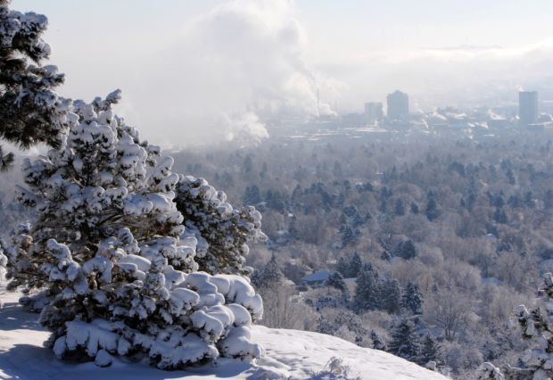
According to my records, the last time, my small town of Forsyth Missouri, saw a string of really cold air was back in February of 2015!

Just to be fair, there have been days scattered here and there where I’d awake to temps in the teens. Sure. But, in general, a fast recovery was just around the corner. That’s not going to be the case, if the forecasts being put out by the National Weather Service is correct!

NWS statement –

'A true arctic front looks to drop into the area sometime during the day on Saturday. High temps will likely occur early in the day and then fall from there. We have not strayed too far from the mean of model guidance for temps this weekend. While there is still decent spread, there is a fairly strong signal that Sunday will be the coldest day with highs potentially remaining in the 20s, possibly colder. Low temperatures in the single digits to teens are also possible. Wind chills below zero are looking increasingly likely this weekend.'

If that statement is true, and if this sort of frigid nonsense were to go on from Saturday late (Feb 6) through Thursday, the 11th of the following work week…. Wow, that will be something to witness. Now here’s a word of caution. Best be prepared!

For a retired man, such as myself, I do know one thing for sure, I’m not likely to want to venture out very often, if the high on a particular day is only in the low thirties! So, in order to avoid that this time, I planned to visit my local grocery store, while it was still relatively warm. My motto, ‘when forewarned of chilly times, stock the shelves, perchance to hibernate, and slumber til better climes’!

For those with crawlspaces, it might be a good idea to check for any open vents as I failed to do years ago when it got very cold. Had I sealed them properly, I would have avoided an expensive plumbers bill!


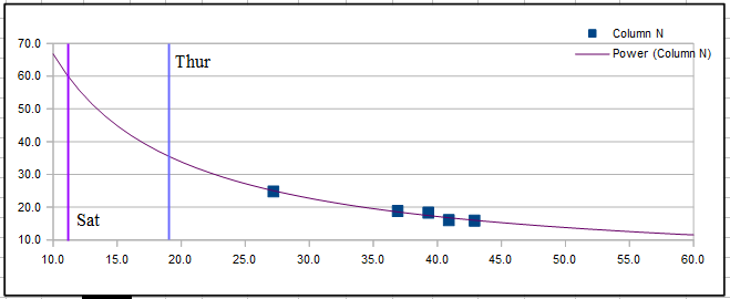
Lastly, as the data above shows, cold spells that last more than a couple of days, can really cause one’s furnace to go into overload. My kilowatt hour use that February in 2015 was just over 1800 kWh’s. That translated to a whopping $234 electric bill for a man who had grown use to only about ninety dollars or so… Bummer.

But before I get too worked up. I plan to calm down, have a cup of coffee and wait for the very much more accurate update that will come along about next Thursday, Feb the 4th! Until then, I will be commenting on my weather site at www.taneyweather.com!