Friday, November 20, 2015

A first touch of the coming winter season!


Forsyth MO – While Friday, November the 20th was forecast to be rather pleasant with temperatures in the mid 50's born on a southeast wind that was to be a bit breezy at times. Later in the afternoon hours, the NWS was predicting that clouds would begin to move in from the west as a sharpening frontal boundary moves toward southwest Missouri from the Plains.

As the front moves through towards midnight, they expect some rain to fall, although not that much. But, once that front does move through, they expect that gusty northwest winds will usher in a much colder air mass VERY quickly. Enough cold air could arrive to allow rain to end as a light rain/snow mix late tonight or early Saturday morning, although no accumulation of any sort was really expected. Oh boy!

This arctic high pressure system will therefore move into our area along about Saturday night, with winds becoming light and variable during the overnight period. This will set the stage for what is looking like the coldest night since March for our area. For the Springfield metropolis, if the temperatures drop below 20 degrees, it will be the first time we will have seen the teens since March 5th of this year. Further south, we can expect thing to not be so brutal!

Good News! The shot of cold will be rather short lived, as temps will rebound into the 40's for Sunday and then will get back in a more seasonal 50's regime as we begin the next work week!

As this shot of cold is in the form of a dress rehearsal (a one day thing), homeowners might want to download a checklist of smart thing to do prior to winter setting up in earnest. Things like getting your car serviced, checking to make sure all house water outlets have their hoses disconnected, checking crawlspace vents, etc.  [www.taneyservices.com]

Wednesday, November 18, 2015

November 21, 2015: An arctic blast?


While southwest Missouri has been given a nice late fall break through most of November, Saturday November the 21st will be a little bit of payback from Old Man Winter! (Apparently, he's nearby and perhaps getting just a bit antsy)!

The seasonal November weather regime we've all enjoyed will begin to move in to a more wintry mode beginning on Friday, November the 29th. Beginning that evening an area of low pressure will dive down across out area from out of the northwest. As moves overhead, moisture levels will be on the dry side, so the weather service is not too concerned about precipitation chances. Some people may see a few snow flurries, but there is no chance for any accumulation!

Right on the heels of the trough will be substantially colder air! Saturday will feel pretty crappy as temperatures will struggle to get out of the thirties! Any wind will only add insult to injury. Then, during the overnight hours, it will be very likely to see lows down in the twenties. It's even possible a few lucky individuals might get a dose of the teens! Holy Murgatroid!

The good news, short term, is that we will see temperatures warming back to seasonal levels (50's and 30's) as we enter the last week of November!

Friday, November 13, 2015

Warm temperature trends still holding in November 2015!


Nice, at least, down where I reside in southwest Missouri. The chart tells the story! It's been over nine degrees above the normal average with no change in site. More like spring than fall, for sure! As a matter of fact, a wide area of heavy rainfall was forecast for the central states with my little town of Forsyth right in the cross hairs!

Saturday, November 7, 2015

Early November 2015 temperature trends!

November 2014 was a real roller coaster ride! I noted that the 17th was not a very nice fall day!


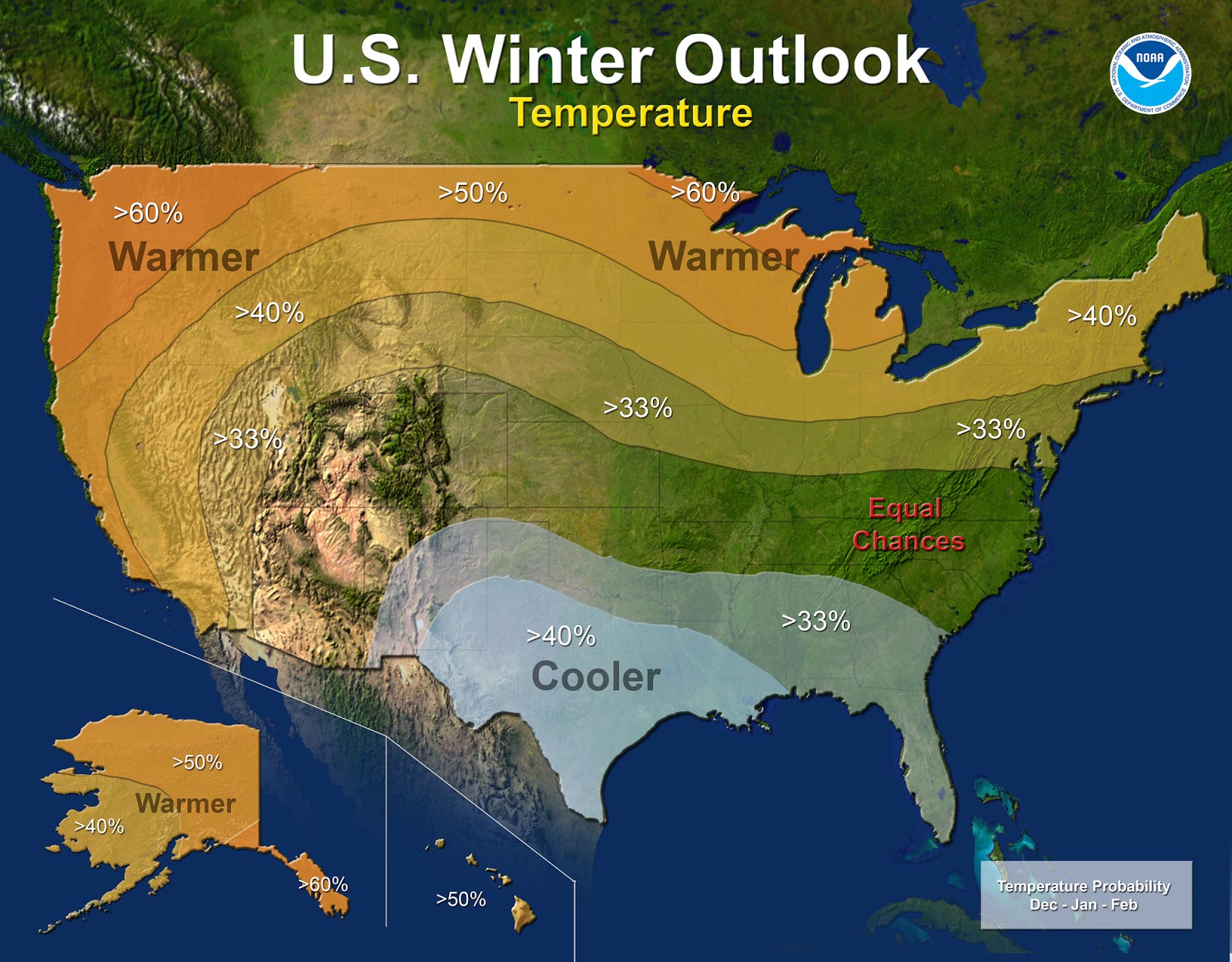
What's in store for the winter of 2015-16?


They say that no one can predict what the weather will do even a week or so down the road, so why am I taking a stab at predicting a whole season?

According to the Farmer's Almanac, the coming winter season here in southwest Missouri will be 'very snowy with typical temperatures'.

The Weather Channel sates, 'A colder than average winter may be on the horizon for portions of the Southwest, Southern Plains, Southeast and East Coast, according to a December 2015-February 2016 temperature outlook released by The Weather Channel Professional Division on Friday.

And then, there's this from the NOAA - 'Forecasters at NOAA’s Climate Prediction Center issued the U.S. Winter Outlook today favoring cooler and wetter weather in Southern Tier states with above-average temperatures most likely in the West and across the Northern Tier. This year’s El NiƱo, among the strongest on record, is expected to influence weather and climate patterns this winter by impacting the position of the Pacific jet stream.'

So what's the distillation of those three sources? I'd tend to sum them up by stating that it might be a good idea to invest in a snow shovel early on.... You can always check in at www.taneyservices.com for up to the minute weather graphics and forecasts for southwest Missouri!

Friday, November 6, 2015

November 2015 starts out warm!

A  note from the log of the National Weather Service, posted on  222 AM CST SAT NOV 7 2015 read in part 'One final note, mean zonal westerlies are being shown through the extended forecast. This pattern will provide above normal temperatures for the Ozarks region through the foreseeable future. This is much different than years past heading into the cold season.'

Wednesday, January 28, 2015

Just one more month to go!

The first of February 2015 is just a few days away, and to me, that marks the beginning of the end for winter! The sun will noticeably rise higher and higher about the horizon in the northern hemisphere and as it does, more and more energy in the form of solar insolence will reach the chilled earth.

Where I reside in southwest Missouri, the average temperature for February (as measured at the National Weather Service station in West Plains, MO) comes in at 38°F - with the average high is 48°F and the average low is 26°F. I use this location for temperatures and rainfall as Forsyth lies on about the same latitude and therefore shares much of the same climate. Rainfall will, hopefully be about 3 inches, although we certainly could use more! For anyone with an interest I have live climatic data available at www.taneyservices.com.

By the end of February, the many and varied signs of spring will be readily apparent as some trees and plants begin to blossom. I can hardly wait!