


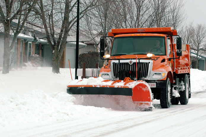
NWS (edited and paraphrased by this site) – A upper (frontal) wave that is currently situated over the central north Pacific will move onshore into the Pacific NW late Friday night then proceed to dig southeast into the southwest U.S. early this coming weekend. Guidance varies, but the mean/median guidance does point to an increasing chance for snow on Sunday and Monday. Hard to be too specific with amounts given where this system initialized, but there is a general agreement concerning the high potential for accumulating snow. System will run into a southwest to northeast baroclinic zone and southwest Missouri will be on the (very) cold side of the zone, with temperatures in the single digits and lower teens, during this time. Initially, precip may fight some dry air with a weaker first wave Sunday/Sunday night, but a second wave (potentially) will bring additional snow on Monday. [How’s that for hedging our bets!]
The forecast snow amounts for now will be inherently somewhat conservative given that it is a model blend. It does yield 3-5 inches from northwest to southeast over the CWFA or County Warning Forecast Area (official). Concerned that the NBM (National Blend of Models) snow ratios are too low, ran a quick snow forecast based on 50th percentile for snow ratio guidance (close to 20:1) which yielded snow amounts about 2-3 inches higher (unofficial). We will definitely need to keep an eye on this system. Given how cold it will be, snow ratios will be high and will easily accumulate on a very cold ground.
No matter how you slice up the day, Saturday the 13th of February, is going to pose a problem for many all over the central part of the the US.
Let me begin with the National Weather Services forecast:
‘By Thursday Feb 11, a reinforcing shot of cold air is expected to slowly filter into the region. This will keep daily highs in the lower to middle 20’s through the upcoming weekend. Cannot rule out highs in the upper teens across central Missouri. Overnight lows through the upcoming weekend will fall into the single digits to lower teens. Add in a light wind and wind chill values will make it feel closer to zero or below. This prolonged period of much below normal temperatures could potentially hang on through the middle of February. However, it is worth noting that some model guidance has backed off a bit on how far south the very cold air mass digs in. This will be assessed in future forecasts.’
So, starting with Thursday, it’s going to get really cold outside. And the very frigid core of that arctic invasion will occur on or about Saturday. (Remember to keep an eye on your pets).
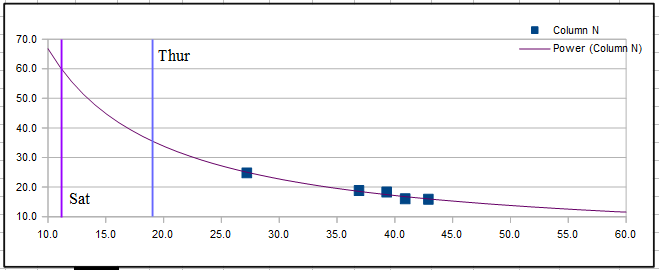
The above scatter chart (that was started on Feb 3) compares actual average temps versus power used. It’s a neat tool that can allow one to predict power demands in the future based on what has happened in the past. (The red line is a power trend line to help with the visualization). Note that on Saturday, with a projected Hi of 21° and a Low of 0° the average temp for the day would be close to 11°. Then it’s easy to see that the purple line representing that average would indicate a power use of 60 kWh’s. That amount of power used would work out costing me ~ 60 kWh * 1.2535/kWh (Liberty Utility rate) = ~$8 for just that one day!
The hope is that this bolus of cold air will not penetrate as far southward as predicted. www.taneyweather.com

Just to be fair, there have been days scattered here and there where I’d awake to temps in the teens. Sure. But, in general, a fast recovery was just around the corner. That’s not going to be the case, if the forecasts being put out by the National Weather Service is correct!
NWS statement –
'A true arctic front looks to drop into the area sometime during the day on Saturday. High temps will likely occur early in the day and then fall from there. We have not strayed too far from the mean of model guidance for temps this weekend. While there is still decent spread, there is a fairly strong signal that Sunday will be the coldest day with highs potentially remaining in the 20s, possibly colder. Low temperatures in the single digits to teens are also possible. Wind chills below zero are looking increasingly likely this weekend.'
If that statement is true, and if this sort of frigid nonsense were to go on from Saturday late (Feb 6) through Thursday, the 11th of the following work week…. Wow, that will be something to witness. Now here’s a word of caution. Best be prepared!
For a retired man, such as myself, I do know one thing for sure, I’m not likely to want to venture out very often, if the high on a particular day is only in the low thirties! So, in order to avoid that this time, I planned to visit my local grocery store, while it was still relatively warm. My motto, ‘when forewarned of chilly times, stock the shelves, perchance to hibernate, and slumber til better climes’!
For those with crawlspaces, it might be a good idea to check for any open vents as I failed to do years ago when it got very cold. Had I sealed them properly, I would have avoided an expensive plumbers bill!

Lastly, as the data above shows, cold spells that last more than a couple of days, can really cause one’s furnace to go into overload. My kilowatt hour use that February in 2015 was just over 1800 kWh’s. That translated to a whopping $234 electric bill for a man who had grown use to only about ninety dollars or so… Bummer.
But before I get too worked up. I plan to calm down, have a cup of coffee and wait for the very much more accurate update that will come along about next Thursday, Feb the 4th! Until then, I will be commenting on my weather site at www.taneyweather.com!

A cold arctic air mass will spill south out of northern Canada
Wednesday night into Thursday and make its way into the Ozarks
behind the cold front for Christmas Eve and Christmas Day. Highs
on Thursday will struggle into the 30's with lows Christmas morning
in the teens. The combination of temperatures in the teens and
winds from 5 to 15mph Christmas morning will allow some wind chill
readings to fall into the single digits for parts of the Ozarks,
especially the eastern Ozarks.

The map shown above is a pretty generic weather forecast with my neck of the woods, in southwest Missouri, being pretty average - A bit warmer than normal with little rainfall.
