Monday, January 28, 2013

T-Storms in January! Rough Wx in store for the 29th!


Here it is, not even February 2013, and already the alarms for ‘spring-type storms’ are sounding! Seems to me this global warming thing may really be kicking in!

Jan 29 mid morning!
The National Weather Service is using terms like ‘hail the size of quarters, and ‘damaging winds’ with even a mention of a tornado or two, as part of a forecast for Tuesday, January the 29th. Interestingly, there is also now the possibility of ‘heavy rain’ in that same forecast. An even, if it comes true, that would be very welcome down here in southwest Missouri!

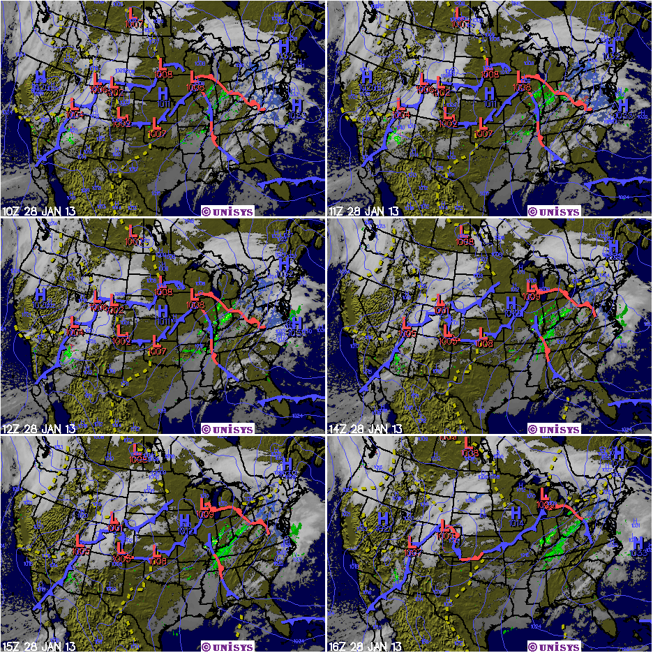
Credit the coming together of all the factors that make for rough weather; a positively tilted frontal system combined with the confluence of cold, warm and dry air and you have the ingredients for some great action this coming Tuesday morning!

Tuesday, January 8, 2013

Video Weather Summary for the first week of January 2013


A rather funny first attempt using Open Office, a video cam and a screen capture product called Snagit! This video is best viewed in the small format. Even if you don't like weather topics, it's fun watching me stumble through it. Thanks!

Thursday, January 3, 2013

Random thoughts concerning the weather!


2012 – Farewell!

Yet another in a string of strange weather years for the southwest Missouri area. According to the National Weather Service located in Springfield Missouri, 2012 was the 2nd warmest and the 10th driest year on record. We also remained in a moderate to severe drought situation depending on exactly where you called home. Now, with 2013 just beginning, lots of people who depend on moderate temperatures and plentiful amounts of rainfall are watching to see what develops!

Micro-weather stations are very cool!

All across the country weather enthusiasts, young and old, have shelled out good money to erect so-called micro-weather stations that fed their data into popular sites like the Weather Underground! By going to the radar display and selecting Wundermaps, you can observe any of thousands of stations, many of which will no doubt be close to where you live. Another piece of software, you can download called the Weather Exchange, can provide you with a quick summary of local stations in an informative display right on your desktop. This is a great little app to have displayed when conditions outside get a little on the wild side!

Global warming! I wonder….

Anyone who is not stone cold dead is probably aware that our world is warming up. At least that is the opinion of many scientists and lay persons of some note. After all, a warming planet could mean a rapid melting of the ice in Polar Regions. And, thus, many coastal locations in America as well as other countries are worried about the effects that a rising sea level would have on their lives.

But here’s the real reason to worry. Even the most educated climatic scientists will admit that the complexity of the earth’s environmental systems are far beyond the keen of mere men. The truth be told, nobody really knows what the effect of seven billion people; living, breathing, defecating and otherwise interacting will have on the planet over the next one or two decades. All they do know is that carbon dioxide levels (currently at 392 ppm) are already way above anything seen in the last million years and that other planet warmers like methane are being to get added to the atmosphere in breath-taking (literally) amounts! One scientist put it as well as any, I think, when he was heard to remark, ‘Something’s going to pop, we just don’t know what, when or where!’  

Sunday, December 30, 2012

Winter weather and New Years could be a bad mix!


As the year 2012 finally draws to a close, it looks as though Mother Nature is going to throw the Forsyth Missouri area one last slush ball!

I find it equally, both amusing and concerning, that whenever those giant weather computers can’t agree on a model forecast. Some areas of the country are naturally more difficult for them than others due to climatic and geographic peculiarities. Forsyth, Branson and even Springfield Missouri just happen to be one of those areas! That said, the challenge for New Years will be to figure out who gets snow, who gets only wet and who gets a little ice!

As of this posting on Sunday morning, the best thinking out of the National Weather Service in Springfield will be for ‘slush’ south of the I44 corridor and snow to the north. And, there may not be much of either as the plume of moisture streaming in from the Pacific will be traveling over some high elevations before making its way into our region. And when it does get here, the lower levels of the atmosphere will be quite dry. It will take some time for that body of air to become saturated enough to produce much of anything in the way of precipitation. In addition, yet another plume of moisture that they were watching come out of the Gulf also looks to be pretty much ‘scoured out’.

The bottom line for Tuesday will be all about timing as a cold front sliding in from the north begins to mix it up with the incoming Pacific moisture. The weather service is still sticking with the idea that much of the county wide area will see some snow overnight tonight (Sunday) which will change over to drizzle during the daytime hours on Tuesday and then become problematic after nightfall. The main concern in all of this forecast will be the chance for slick bridges and a few spots in low lying areas. So be on your toes if you’re traveling at those times.

Saturday, December 29, 2012

Weather for New Years Eve termed problematic!

Due to the complexity of the thermal profiles as seen by the weather computers, the model predictions are all having a hard time with the type of moisture that will fall from the heavens on New Years Eve, be it snow or rain or both! All the models are in agreement that we will get a ‘slug of pacific moisture’ across the countywide area beginning sometime around midnight Sunday and that it should persist on through the early morning hours on Monday. (This system may even be supplemented with a shot of low level moisture from the Gulf just to spice things up a bit)!

At any rate, it mat be touch and go as to who gets the frozen stuff and who does not. The most likely scenario for the Forsyth area will be for us to see an all snow event during the nighttime hours of early Tuesday with a change over to rain or mist sometime after 6AM. This mess will persist on through the day and into Tuesday night with a light snow redeveloping after dark on Tuesday evening. Accumulations, assuming the rain doesn't melt everything, could be from 1 to 3 inches.

The real fly in this ointment will be the possibility of slick conditions forming in some low lying areas and bridges on a night when many people will be out celebrating the New Year. Travelers would be encourage to stay updated during this period of time and to plan accordingly.

Wednesday, December 26, 2012

We ducked a bullet this time!


While I was sad that all the kids in Forsyth missed out on a white Christmas (by geographical inches as it turned out), it’s worth noting that this particular storm caused (is causing) a lot of grief all up and down the eastern portions of this country. Three people died and scores have watched as their plane rides home from the Holidays were canceled. Areas like the Connecticut seaboard are going to be lashed even as that state is still digging out from the effect of Sandy. Gosh! Tornadoes, ice and blizzards! All of which is perfectly normal in December. What?

What interests me as a resident of southwest Missouri, however has bee the rather rapid change from near normal weather conditions to…something else. Even the Weather Service will admit that computer models are ‘all over the board’ as they try to deal with the next system coming in from the West Coast. This winter just might yet be one for the books!

Sunday, December 23, 2012

Weather trends for SW Mo. for January 2013


With the El Nino Southern Oscillation looking to stay more or less normal at least through mid 2013, I don’t think that configuration will be much of a factor for the month of January 2013. However, what is of interest is the swing of the Arctic Oscillation from a slightly positive posture to one that is looking more negative! Could this change be tied in some way to the historic rate at which the arctic sea ice is melting as some scientists think? I’m not sure, but what is sure will be an increased chance for the jet stream to allow really cold air to invade the North American continent as we move into January and February. Add that to the slightly improving chances for precipitation across the Central Midwest and my thinking is that there is a somewhat increased likelihood that southwest Missouri will see periods of extreme cold along with some form of wintery precipitation. Well, only time will tell!

Disclaimer: The author is not credentialed as any form of a scientist, climatic or otherwise.