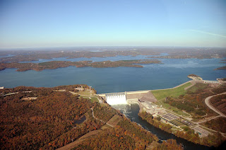
Monday, February 25, 2019

Bull Shoals water levels may hold steady!

River Run Park in trouble!
Forsyth MO. - As a local who likes to enjoy two parks that grace the area, I had taken a keen interest in tracking the current rapid rise of waters in the the Bull Shoals Lake. As of this post, one of the two parks, River Run had begun to flood out. However, Shadowrock was still high and dry. At least for now.
Minor drop in level observed on Feb 25
 What was encouraging to me was fact that the rate of increase had slowed quite a bit. even to the point where I could hope to see it decline a bit in the later part of February. The flies in the ointment here were two; water levels at Beaver Lake continued to be about two feet above full pool and release rates at the Bull Shoals dam near the Arkansas border were still being restricted due to the time of year. And, as spring was still a few weeks off, I found that troubling.


The good news was that, while rain would likely occur over the next ten days, it also appeared to be on the light side of things! So, if we don't get much rain and if Bull Shoals dam does increase their releases and so on and so forth.... at least one of the parks might be spared from flooding.

Note: My estimates of when a park might flood out are just that, estimates.

Update: Army Corps of Engineers to Open Two Gates at Table Rock Dam on Tuesday, March 5, 2019. They needed to perform maintenance on two turbines - I was not sure if this would affect Bull Shoals.


Will early March Wx see improvements? Probably not!


So, while we all enjoy a mini-dry spell for a day or two, there exists more chances for rain along about mid week. Confidence was increasing in seeing shortwave energy sweeping through Tuesday night thru Thursday. It is anticipated this will bring chances for light rain across the region throughout the day on Wednesday. However, with the intrusion of colder air late Wednesday night into Thursday, the concern becomes the possibility of seeing mixed wintry precipitation, (most of which is likely to fall north of the I-44 corridor). Otherwise light rain all around. meh

Then, as we edge on out of February and into the first weekend of March 2019, another frontal system will take aim at the region by Friday (March 1) as a warm front lifts north across the region.

While the models continue to vary on solutions, it does appear there is a potential for some instability getting into Missouri and will be something to keep an eye on. This system is quickly overcome by a much stronger intrusion of high pressure and colder temperatures. Highs next Saturday through early next week look to only top out in the 30s with lows in the teens/lower 20s across the region. Current models suggest a few chances of seeing light snow to go along with the below average temperatures next weekend. Double meh

www.taneyweather.com

Friday, February 22, 2019

Past four years of rain in Forsyth MO!

Forsyth MO - Just for fun, I thought to post the last four years of rainfall as recording in the Forsyth Missouri area. The readings were obtained from a Davis Weather Monitor III rain gauge. I'll try and update this on a monthly basis as we move into 2019! Click on graphic to enlarge.


Wednesday, February 20, 2019

Asking why?

Forsyth MO. - As of this post on Feb 20, 2019, one of two small Parks was in the very early stage of flooding out. River Run used to be a fun place for many area citizens to visit, RV camp or fish from, but that has not been the case very often as of late. Now, it would appear to be heading for Davy Jones locker as water was making an incursion on its northwestern border. My question is why?

The graphic at right show the record of lake water levels for the last few floods. In 2018, while there was only minor flooding, it didn't matter as the Park was shut down due to bridge construction. But, in 2015 and 2017, both River Run and Shadowrock were under many feet of water. And, yes, I realize that those two areas are considered flood plains. That said, it still brings into question how well water management was being conducted by the Corps of Engineers? This offshoot branch of the Army is basically responsible for what happen to three reservoirs; Beaver Lake, Table Rock Lake and Bull Shoals. Sandwiched between the last two is Taneycomo Lake, a narrow body of water bordered by Table Rock dam one end and Powersite dam on the other. And that area is also considered a flood plain and includes the Landing in Branson! Taneycomo's water level has to be kept within relatively narrow limits as housing and commercial interests have been built close to the waters edge. In some cases these dwellings are only a few feet above the normal water level and that's a problem for everyone whenever the region gets decent rains!

On the left is a stylized graphic of the three main reservoirs with Taneycomo sandwiched in. When combined, they represent a tremendous body of water that has to empty into the White River just down stream of the Bull Shoals dam. And that thar is the problem. In most every season, the White River cannot take in a boatload of discharge, especially during the winter months! so, when we've even only had an average amount of rainfall, the levels Beaver get pretty far up that - currently at 1122 feet and some change. After a heavy spring rain, the White river become the choke point while Bull Shoals is permitted to completely flood so as to spare folks living near Table Rock and Taneycomo.

So, what the solution? Is there even a solution? Probably not - The best case scenario would be a prolonged drought, next would be a major re-construction of the White River. One would hurt agriculture and the other would break the bank. So, for now, I'll have to be content to stand by and watch the parks flood.

Monday, February 18, 2019

What the heck is a warm nose?

Note the red line at the btm as it moves from close to zero Celsius to warmer temps and then back to freezing with height!
In weather terms, a 'warm nose', in the winter time, is a layer of air at about 850 millibars or 5000 feet that is warmer than either the freezing air above or below it. It can cause problems associated with any precipitation that might fall through it resulting, for example in snow reaching that level and then melting only to begin to refreeze as it get closer to the ground. The result, generally, is some form of sleet, but can become freezing rain if other conditions permit. So when a weather forecaster is talking about a warm nose of air moving into colder air, he or she is tacitly warning the viewer about possible forms of precipitation that would be different from rain or snow, i.e. some form of ice.

Will Forsyth MO area Parks flood in 2019?

Forsyth MO. - I was very much looking forward to a few new features in my small town of Forsyth Missouri in southwest Missouri this coming spring. A new bridge over Bull Shoals, a new roundabout and two parks that all looked to be in great shape!

But wait! There might be a fly in the ointment and that was the potential for both River Run and Shadowrock Parks to be flooded out early in the coming 2019 season! How could this happen, you ask?
Click to expand
Well, my fears grew somewhat when I realized that the water levels in Bull Shoals as well as the other two reservoirs (Beaver and Table Rock Lakes) upstream of it were much higher than they normally were (see graphic above). And with the spring season not even here, I noted that River Run was already becoming invaded on its northwestern shore! I just could not see how the Corps of engineers were going to manage their way out of flooding problems even if we have a typical amount of rain in March and April. (Perhaps they were hoping for a mini drought to occur....).

Graphic 2
As I considered the situation, and the fact that our rainfall had not been all that excessive over past six months (graphic 2), I turned my focus on the Bull Shoals dam down by the Arkansas border. I had to guess that they were simply unable to release as much water as they normally would possibly due to the time of year, when water absorbing foliage was not present. (Either that was the case or there were other issues occurring somewhere between that point and the gulf that I was unaware of...).

Whatever, the answer to the flooding question was going to resolve itself over the next couple of months, of that I was certain, I was just hoping for a chance to get in some 'Park' time early in the spring before anything of a wet nature happened.

Update: Feb 20, 2019 - River Run Park. The flooding of part of this park had begun!

Update: Feb 24 - With just a few days to go in the month, it was looking as though the River Run Park area would be flooded out! And, it wasn't even the start of the spring season! We'd really need a serious dry spell for, say, the first few weeks of March to get the levels back down.


Monday, February 11, 2019

Worst case scenario for Table Rock Dam!

The worst-case scenario of a catastrophic floodwater discharge from Table Rock Lake using the auxiliary floodgates would roughly resemble this: 

Water Level at 931 Feet:  Table Rock Lake is at full flood capacity. The ten Tainter gates are opened to accommodate additional lake inflow from the White River Basin including the James River and Beaver Lake discharge.

Water Level at 937 feet: Table Rock Lake is now 6 feet above flood capacity. The ten Tainter gates are opened wider in an effort to stabilize reservoir rise. Outflow from the Lake under these circumstances will be nearing 200-300 thousand cubic feet per second (CFS).

Water Level at 942 feet: Table Rock Lake is 11 feet above flood capacity and at its "design pool", or the maximum elevation that the reservoir is engineered to reach, under "probable maximum flood" scenarios. The dam’s ten Tainter gates will be fully raised to their maximum height of approximately 30 feet letting loose 550 thousand CFS into Lake Taneycomo. This scenario would effectively submerge and destroy the powerhouse, power transmission grid, hatchery, and wreak serious destruction down stream. An illustration of how Table Rock’s ten spillways might appear under these circumstances mimics this: the floodgates will extend up and out from the structure, like eyebrows, shadowing the concrete spillways!

Water Level at 947 feet: Table Rock Dam would be at its maximum capacity and water would be at the very top of the dam. The auxiliary spillway would be brought online, in concert with Table Rock’s fully opened floodgates. This catastrophic or "last resort" protocol releases 1 million CFS of lake waters into Taneycomo and deals dreadful destruction to Branson, Hollister, Point Lookout and possibly the Powersite Dam. At this point there is a danger of water overtopping the concrete dam and breaching the earthen structure, which imminently leads to cataclysmic structural failure and the uncontrolled release of the Table Rock Lake impoundment—nearly 3 million CFS of water.

Historically, Table Rock Lake has experienced a record crest of 935.47 feet, which occurred on April 27, 2011.

In December 2015, the dam released 72,000 CFS at its peak. This is the highest amount ever released! [Information source: https://en.wikipedia.org/wiki/Table_Rock_Lake]

Sunday, February 10, 2019

Potential for flooding in 2019 at Bull Shoals!


Forsyth MO. - Some mid February 2019 observations concerning the chances for seeing Bull Shoals flood once again. I got interested in watching the rainfall rates very early in the season as we were still in the middle of winter.  Above is a graphic that shows the current water level of the Bull Shoals Lake in feet above mean sea level. The other two historical lines concerned the levels in 2015 and 1017 -  two years that witnessed flooding levels that also meant that both the Shadowrock and River Run Parks remained closed for the summer and fall seasons. Last year, River Run was closed due to the construction of a new bridge, but many local folks and vacationers were hoping for a chance to enjoy both parks if they could remain high and dry!

I planned to follow up on this post from time to time, especially as we got more into the meat of the spring season. I noted that back in 2015, the level started going up in early March while the 2017 season had a later start. When and if the water rises above 670 some flooding of River Run would occur. Shadowrock, being at a slightly heavier elevation would then flood once the water rose over the 675 foot mark. That’s as best I can remember at any rate.

Feb 11, 2019 - A good bit of rain fell overnight and also looked to continue for much of Monday as a system slowly made its way off to the east. Beginning Tuesday, Feb 12, I plan to post the water levels at the two main reservoirs that are upstream of Bull Shoals. Below is a graphic of the levels on Feb 11. So, stay turned.

[All three of the lakes were at or above full power pools. Beaver was.33 feet above, Table Rock was .61 feet above and Bull Shoals was 1.91' above.]

Feb 12, 2019


www.taneyweather.com